Approximate Location Map
Large Map »
Latitude: 53.8263 / 53°49'34"N
Longitude: -1.2961 / 1°17'46"W
OS Eastings: 446428
OS Northings: 436896
OS Grid: SE464368
Mapcode National: GBR MSD6.54
Mapcode Global: WHDBN.2321
Plus Code: 9C5WRPG3+GG
Entry Name: Chapel of St Mary
Listing Date: 3 February 1967
Grade: II*
Source: Historic England
Source ID: 1148440
English Heritage Legacy ID: 326358
ID on this website: 101148440
Location: North Yorkshire, LS24
County: North Yorkshire
District: Selby
Civil Parish: Lead
Traditional County: Yorkshire
Lieutenancy Area (Ceremonial County): North Yorkshire
Church of England Parish: Saxton All Saints
Church of England Diocese: York
Tagged with: Church building
LEAD CHANTRY LANE (bridle
SE 43 NE path)
(north side)
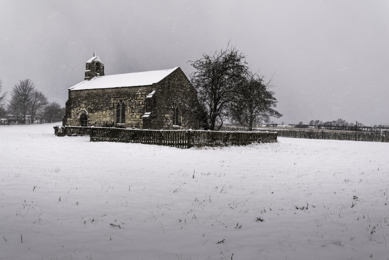
3/20 Chapel of Saint Mary
3.2.67
II*
Chapel. C12 with C13 angle buttresses and C14 windows, with later repairs.
Magnesian limestone coursed rubble with stone slate roof. 2 bays. Diagonal
buttresses to west end and angle buttresses to east, all with off-sets.
South entrance a round-arched plank door with continuously moulded surround
under hood-mould. South and north sides have 2-light, straight-headed
windows with pointed, trefoiled lights. Bell turret to west gable. East
end has 2-light pointed window with reticulated tracery under hood-mould.
Interior: stone altar table incorporates a medieval tomb slab bearing a
foliated calvary cross. Set in the floor are 5 medieval inscribed slabs to
the Tyas family. Medieval font with square base widening to circular rim.
Late medieval benches. Triple-decker C18 pulpit. Inscription to rear of
door: 'RE-DEDICATED BY THE BISHOP OF WHITBY NOV. 6TH. 1932: / BUILT ABOUT
1150 A.D. / This Chappell Repaired in 1784 / RESTORED BY VOLUNTARY LABOUR IN
CHARGE OF / JACK WINTERBURN, 1932 A.D. / REV. T. BOTTOMLEY / VICAR OF
SAXTON'. Pevsner N, Yorkshire, The West Riding, 1979, p 301.
Listing NGR: SE4642836896
External links are from the relevant listing authority and, where applicable, Wikidata. Wikidata IDs may be related buildings as well as this specific building. If you want to add or update a link, you will need to do so by editing the Wikidata entry.


Other nearby listed buildings
