Approximate Location Map
Large Map »
Latitude: 54.4855 / 54°29'7"N
Longitude: -0.6158 / 0°36'56"W
OS Eastings: 489772
OS Northings: 510893
OS Grid: NZ897108
Mapcode National: GBR SJ4K.GV
Mapcode Global: WHG9Y.HJZ7
Plus Code: 9C6XF9PM+5M
Entry Name: The Whitby Way
Listing Date: 4 December 1972
Grade: II
Source: Historic England
Source ID: 1148345
English Heritage Legacy ID: 326540
ID on this website: 101148345
Location: Whitby, North Yorkshire, YO21
County: North Yorkshire
District: Scarborough
Civil Parish: Whitby
Built-Up Area: Whitby
Traditional County: Yorkshire
Lieutenancy Area (Ceremonial County): North Yorkshire
Church of England Parish: Whitby St Mary
Church of England Diocese: York
Tagged with: Hotel
1.
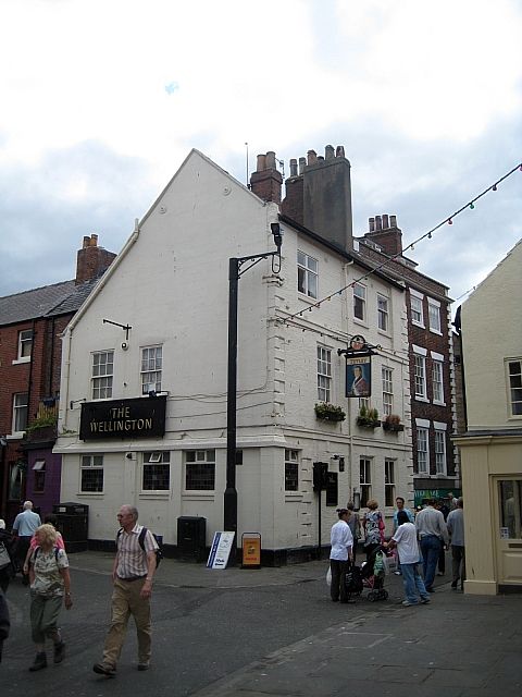
1811 BAXTERGATE
(South Side)
Wellington Hotel
NZ 8910 3/48
II
2.
Mid C18. 3 storeys in painted brick. Bands between storeys. Rusticated
quoins. Plinth. 3 windows, double-hung sashes, glazing bars, to 1st floor.
One blocked window on ground floor and one modern window inserted to left.
Wellington Road front remodelled.
Listing NGR: NZ8977210893
External links are from the relevant listing authority and, where applicable, Wikidata. Wikidata IDs may be related buildings as well as this specific building. If you want to add or update a link, you will need to do so by editing the Wikidata entry.


Other nearby listed buildings
