Approximate Location Map
Large Map »
Latitude: 54.486 / 54°29'9"N
Longitude: -0.6151 / 0°36'54"W
OS Eastings: 489813
OS Northings: 510954
OS Grid: NZ898109
Mapcode National: GBR SJ4K.MN
Mapcode Global: WHG9Y.JH9T
Plus Code: 9C6XF9PM+9W
Entry Name: 61, Baxtergate
Listing Date: 4 December 1972
Grade: II
Source: Historic England
Source ID: 1316374
English Heritage Legacy ID: 326546
ID on this website: 101316374
Location: Whitby, North Yorkshire, YO21
County: North Yorkshire
District: Scarborough
Civil Parish: Whitby
Built-Up Area: Whitby
Traditional County: Yorkshire
Lieutenancy Area (Ceremonial County): North Yorkshire
Church of England Parish: Whitby St Mary
Church of England Diocese: York
Tagged with: Building
1.
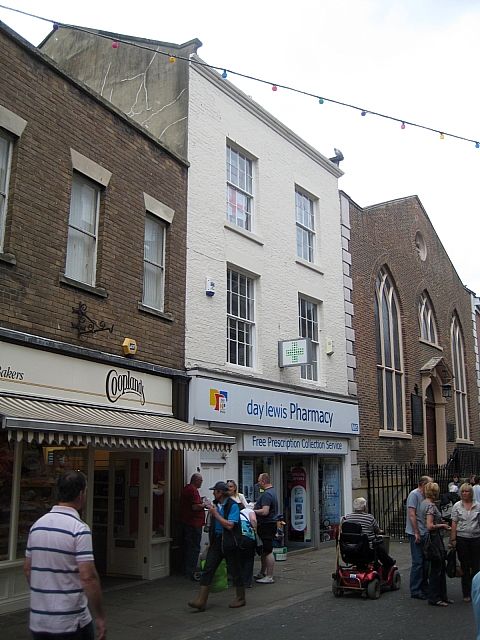
1811 BAXTERGATE
(North Side)
No 61
NZ 8910 3/52
II GV
2.
Early Cl9, 3 storeys in brick. Pantile roof. 2 windows, flat arches,
double hung sashes with glazing bars. Cornice to parapet. Cl9 shop front
with Corinthian pilasters and entablature, plate glazing, double door.
No 61 forms a group with Church of St Ninian.
Listing NGR: NZ8981310954
External links are from the relevant listing authority and, where applicable, Wikidata. Wikidata IDs may be related buildings as well as this specific building. If you want to add or update a link, you will need to do so by editing the Wikidata entry.


Other nearby listed buildings
