Approximate Location Map
Large Map »
Latitude: 54.487 / 54°29'13"N
Longitude: -0.6146 / 0°36'52"W
OS Eastings: 489848
OS Northings: 511062
OS Grid: NZ898110
Mapcode National: GBR SJ4K.RB
Mapcode Global: WHG9Y.JHK2
Plus Code: 9C6XF9PP+Q5
Entry Name: 49, Flowergate
Listing Date: 23 February 1954
Grade: II
Source: Historic England
Source ID: 1148236
English Heritage Legacy ID: 326770
ID on this website: 101148236
Location: Whitby, North Yorkshire, YO21
County: North Yorkshire
District: Scarborough
Civil Parish: Whitby
Built-Up Area: Whitby
Traditional County: Yorkshire
Lieutenancy Area (Ceremonial County): North Yorkshire
Church of England Parish: Whitby St Mary
Church of England Diocese: York
Tagged with: Building
1.
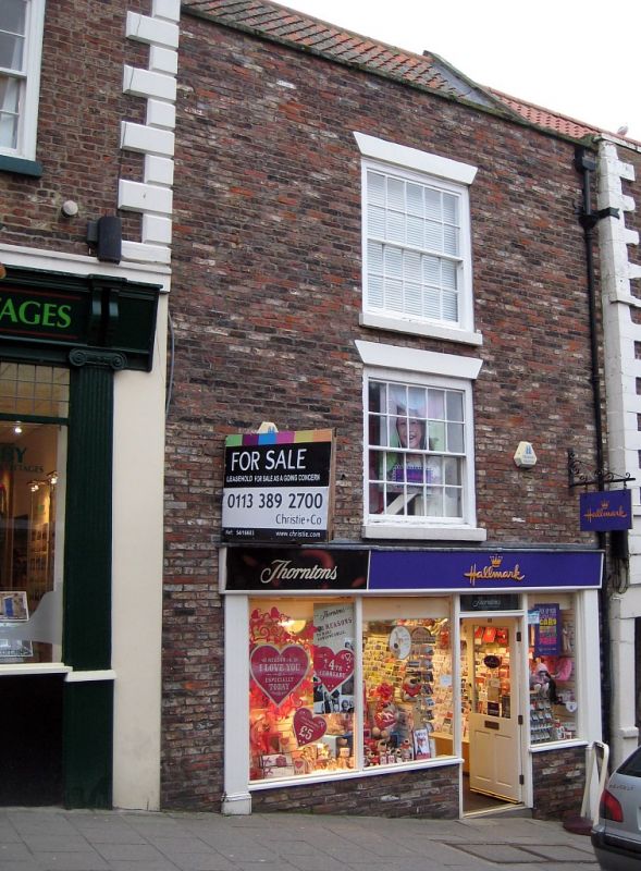
1811 FLOWERGATE
(North Side)
No 49
NZ 8911 1/129 23.2.54.
II GV
2.
C18. 3 storeys in brick. Pantile roof. Parapet. Brick bands between
storeys. One window, flat stone arch, double-hung sash with glazing bars.
Shop front with modern glazing. Modern door set back.
Nos 47 to 50 (consec) form a group with No 1 St Anne Lane.
Listing NGR: NZ8984811062
External links are from the relevant listing authority and, where applicable, Wikidata. Wikidata IDs may be related buildings as well as this specific building. If you want to add or update a link, you will need to do so by editing the Wikidata entry.


Other nearby listed buildings
