Approximate Location Map
Large Map »
Latitude: 54.4877 / 54°29'15"N
Longitude: -0.6146 / 0°36'52"W
OS Eastings: 489846
OS Northings: 511150
OS Grid: NZ898111
Mapcode National: GBR SJ4K.R1
Mapcode Global: WHG9Y.JGKG
Plus Code: 9C6XF9QP+35
Entry Name: 17, Haggersgate
Listing Date: 4 December 1972
Grade: II
Source: Historic England
Source ID: 1316431
English Heritage Legacy ID: 326823
ID on this website: 101316431
Location: Whitby, North Yorkshire, YO21
County: North Yorkshire
District: Scarborough
Civil Parish: Whitby
Built-Up Area: Whitby
Traditional County: Yorkshire
Lieutenancy Area (Ceremonial County): North Yorkshire
Church of England Parish: Whitby St Mary
Church of England Diocese: York
Tagged with: Building
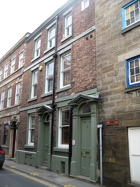
1.
1811 HAGGERSGATE
(East Side)
No 17
NZ 8911 1/147
II GV
2.
Early Cl9. 3 storeys in brick. Stone eaves cornice. 3 sash windows, brick
arches, no glazing bars. Brick bands between storeys. Open pedimented
doorcase with fluted pilasters and semi-circular fanlight, no glazing bars.
All the listed buildings in Haggersgate (East Side) form a group.
Listing NGR: NZ8984611150
External links are from the relevant listing authority and, where applicable, Wikidata. Wikidata IDs may be related buildings as well as this specific building. If you want to add or update a link, you will need to do so by editing the Wikidata entry.


Other nearby listed buildings
