Approximate Location Map
Large Map »
Latitude: 54.4714 / 54°28'16"N
Longitude: -0.6294 / 0°37'45"W
OS Eastings: 488924
OS Northings: 509309
OS Grid: NZ889093
Mapcode National: GBR SJ1Q.JX
Mapcode Global: WHG9Y.9WK1
Plus Code: 9C6XF9CC+G7
Entry Name: 8, High Street
Listing Date: 4 December 1972
Grade: II
Source: Historic England
Source ID: 1280843
English Heritage Legacy ID: 326862
ID on this website: 101280843
Location: Ruswarp, North Yorkshire, YO21
County: North Yorkshire
District: Scarborough
Civil Parish: Whitby
Built-Up Area: Whitby
Traditional County: Yorkshire
Lieutenancy Area (Ceremonial County): North Yorkshire
Tagged with: Building
1.
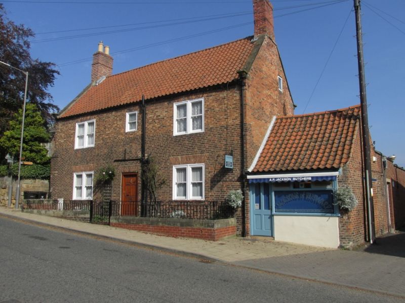
1811 HIGH STREET
(East Side)
RUSWARP
No 8
NZ 8809 10/533
II
2.
C18 origin. 2 storeys in brick. Pantlile roof with 2 chimneys at gable
ends. 2:1:2 windows, the outer being paired double-hung sashes in flush
frames, no glazing bars. On ground floor, 4 paired sashes flanking modern
glass door, brick voussoirs.
Listing NGR: NZ8892409309
External links are from the relevant listing authority and, where applicable, Wikidata. Wikidata IDs may be related buildings as well as this specific building. If you want to add or update a link, you will need to do so by editing the Wikidata entry.


Other nearby listed buildings
