Approximate Location Map
Large Map »
Latitude: 54.5586 / 54°33'30"N
Longitude: -0.7913 / 0°47'28"W
OS Eastings: 478262
OS Northings: 518822
OS Grid: NZ782188
Mapcode National: GBR QHXQ.HN
Mapcode Global: WHF8B.TPC5
Plus Code: 9C6XH655+CF
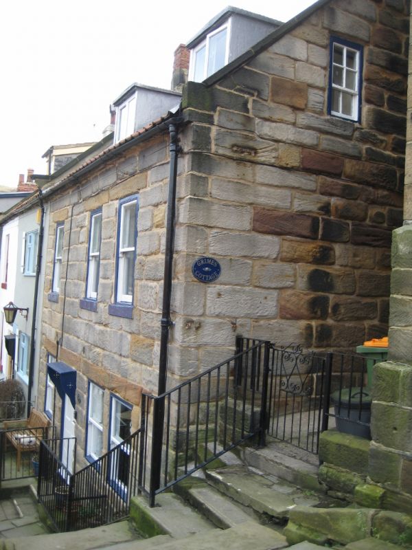
Entry Name: Grimes Cottage
Listing Date: 26 March 1973
Grade: II
Source: Historic England
Source ID: 1148935
English Heritage Legacy ID: 327139
ID on this website: 101148935
Location: Staithes, North Yorkshire, TS13
County: North Yorkshire
District: Scarborough
Civil Parish: Hinderwell
Built-Up Area: Staithes
Traditional County: Yorkshire
Lieutenancy Area (Ceremonial County): North Yorkshire
Church of England Parish: Hinderwell with Roxby and Staithes
Church of England Diocese: York
Tagged with: Cottage
NZ 7818 NW HINDERWELL BARRIS
Staithes
8/64
Grimes Cotttage
26.3.73
GV II
Cottage, early C19. Coursed stone, pantiled roof. Two storeys and attic, 3 win-
dows, late C19 sashes. One larger ground floor window, possibly once ashop.
Plain C20 door. Two later C19 dormers.
Listing NGR: NZ7826218822
External links are from the relevant listing authority and, where applicable, Wikidata. Wikidata IDs may be related buildings as well as this specific building. If you want to add or update a link, you will need to do so by editing the Wikidata entry.


Other nearby listed buildings
