Approximate Location Map
Large Map »
Latitude: 54.5031 / 54°30'11"N
Longitude: -0.6749 / 0°40'29"W
OS Eastings: 485906
OS Northings: 512784
OS Grid: NZ859127
Mapcode National: GBR RJQC.PJ
Mapcode Global: WHG9X.L2TP
Plus Code: 9C6XG83G+62
Entry Name: Village Hall
Listing Date: 10 December 1985
Grade: II
Source: Historic England
Source ID: 1179929
English Heritage Legacy ID: 327272
ID on this website: 101179929
Location: Sandsend, North Yorkshire, YO21
County: North Yorkshire
District: Scarborough
Civil Parish: Lythe
Traditional County: Yorkshire
Lieutenancy Area (Ceremonial County): North Yorkshire
Church of England Parish: Lythe with Sandsend
Church of England Diocese: York
Tagged with: Village hall
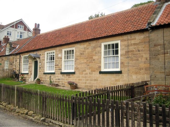
NZ 8512 LYTHE HIGH ROW
Sandsend
14/197
Village Hall
-
GV II
Probably early C19. Coursed stone, modern pantiled roof. One storey. 4 win-
dows, door between first and second. Sashes with glazing bars in wood archi-
traves with stone lintels and cills. Bracketed flat door hood. Included mainly
for group value.
Listing NGR: NZ8590612784
External links are from the relevant listing authority and, where applicable, Wikidata. Wikidata IDs may be related buildings as well as this specific building. If you want to add or update a link, you will need to do so by editing the Wikidata entry.


Other nearby listed buildings
