Approximate Location Map
Large Map »
Latitude: 51.3228 / 51°19'22"N
Longitude: -2.5027 / 2°30'9"W
OS Eastings: 365068
OS Northings: 158309
OS Grid: ST650583
Mapcode National: GBR JV.WWQR
Mapcode Global: VH89G.K0SR
Plus Code: 9C3V8FFW+4W
Entry Name: Rugbourne Farmhouse and Attached Garden Wall and Gate Piers
Listing Date: 21 September 1960
Grade: II
Source: Historic England
Source ID: 1320758
English Heritage Legacy ID: 32808
ID on this website: 101320758
Location: Rotcombe, Bath and North East Somerset, Somerset, BS39
County: Bath and North East Somerset
Civil Parish: High Littleton
Built-Up Area: Hallatrow
Traditional County: Somerset
Lieutenancy Area (Ceremonial County): Somerset
Tagged with: Farmhouse
ST 65 NE HIGH LITTLETON BUNGAY'S HILL (north side)
7/68 Rugbourne Farmhouse and attached
21.9.60 garden wall and gate piers (formerly
listed as Rugbourne Farmhouse)
11
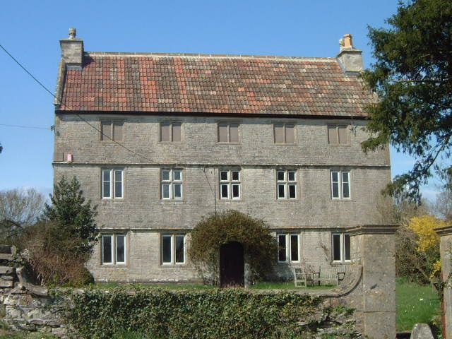
Farmhouse. Late C17. Squared and coursed rubble with flush freestone quoins,
stone openings, copings and double Roman tile roof. South east front of
3 storeys, 5 windows. Ground floor windows are 2-light ovolo mullions with C19
casements, first floor has 3 central cross mullions with 2-light ovolo mullions at
either end, upper floor has 2-light ovolo mullions all blocked. Segmental-headed
and keyed central doorway with moulded architrave and C19 plank door. C19
ironwork porch. Continuous dripmoulds at 1st and 2nd floor levels. Double span
roof with end stone stacks to south east, reconstituted stone stacks to rear.
Side walls have keyed oculi to loft space and some large window openings with
keyed heads and straight cornices: some blocked, others with 6 pane sashes.
Interior. Ground floor left hand room has a contemporary compartmented plaster
ceiling of 4 panels with central roundels and corner foliage sprays. Garden
forecourt has rubble walls with dressed stone copings and plain gate piers, square
on plan, with moulded caps. William Smith the 'Father of British Geology'and
Surveyor to the Somerset Coal Canal Company lodged here 1792-1795 . (R.D. Reid,
Some Buildings of Mendip, 1979).
Listing NGR: ST6506858309
External links are from the relevant listing authority and, where applicable, Wikidata. Wikidata IDs may be related buildings as well as this specific building. If you want to add or update a link, you will need to do so by editing the Wikidata entry.


Other nearby listed buildings
