Approximate Location Map
Large Map »
Latitude: 54.341 / 54°20'27"N
Longitude: -0.9352 / 0°56'6"W
OS Eastings: 469321
OS Northings: 494462
OS Grid: SE693944
Mapcode National: GBR PLX7.BM
Mapcode Global: WHF9F.L4VY
Plus Code: 9C6X83R7+CW
Entry Name: Catter Stone
Listing Date: 24 June 1987
Grade: II
Source: Historic England
Source ID: 1149045
English Heritage Legacy ID: 328879
ID on this website: 101149045
Location: North Yorkshire, YO62
County: North Yorkshire
District: Ryedale
Civil Parish: Hutton-le-Hole
Traditional County: Yorkshire
Lieutenancy Area (Ceremonial County): North Yorkshire
Church of England Parish: Lastingham St Mary
Church of England Diocese: York
Tagged with: Architectural structure
FARNDALE EAST BLAKEY ROAD
SE 69 SE
(east side, off)
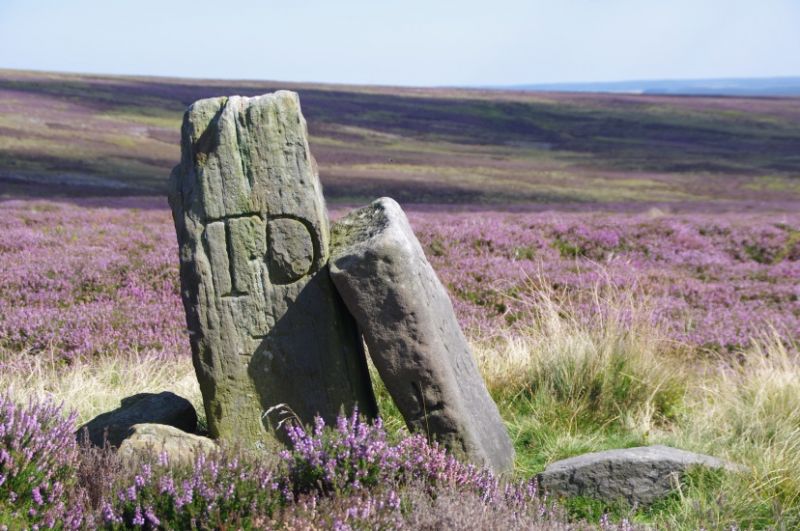
6/45 Catter Stone
- II
Boundary stone. Early C18. Gritstone. Rounghly shaped monolith
approximately 0.85 metres high. West face inscribed "TD" with a benchmark.
A second, taller stone, marked "TD" is propped against the Catter Stone and
is probably also a boundary stone removed from its original site.
Listing NGR: SE6932194462
External links are from the relevant listing authority and, where applicable, Wikidata. Wikidata IDs may be related buildings as well as this specific building. If you want to add or update a link, you will need to do so by editing the Wikidata entry.


Other nearby listed buildings
