Approximate Location Map
Large Map »
Latitude: 54.1938 / 54°11'37"N
Longitude: -1.4589 / 1°27'32"W
OS Eastings: 435399
OS Northings: 477692
OS Grid: SE353776
Mapcode National: GBR LM7Y.YD
Mapcode Global: WHD8M.KVHC
Plus Code: 9C6W5GVR+GC
Entry Name: Mile Post Half a Mile South of Baldersby Village
Listing Date: 27 September 1984
Grade: II
Source: Historic England
Source ID: 1150043
English Heritage Legacy ID: 330384
ID on this website: 101150043
Location: Baldersby St James, North Yorkshire, YO7
County: North Yorkshire
District: Harrogate
Civil Parish: Baldersby
Traditional County: Yorkshire
Lieutenancy Area (Ceremonial County): North Yorkshire
Tagged with: Milestone
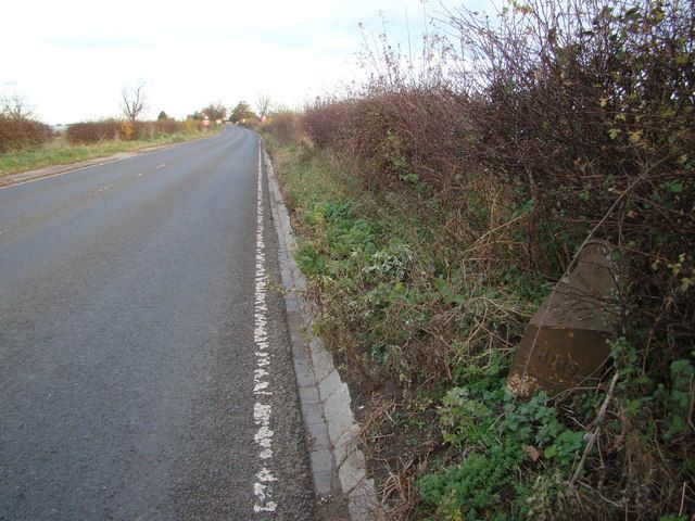
SW 354777 BALDERSBY A61
(east side)
3/8 Mile Post half a mile
south of Baldersby
- village
- II
Mile post. C19. Cast iron. Triangular plan with semi-circular head-
board carrying the words 'North Riding Yorkshire' and circular motif.
Triangular upper face: 'Wath R.D.C.' South face: 'Thirsk 6 miles' and
arrow. North face: 'Ripon 5 miles' and arrow. Top left corner broken
away.
Listing NGR: SE3539977692
External links are from the relevant listing authority and, where applicable, Wikidata. Wikidata IDs may be related buildings as well as this specific building. If you want to add or update a link, you will need to do so by editing the Wikidata entry.


Other nearby listed buildings
