Approximate Location Map
Large Map »
Latitude: 54.1865 / 54°11'11"N
Longitude: -1.4407 / 1°26'26"W
OS Eastings: 436594
OS Northings: 476886
OS Grid: SE365768
Mapcode National: GBR LNC1.W1
Mapcode Global: WHD8T.V13F
Plus Code: 9C6W5HP5+HP
Entry Name: School and School House
Listing Date: 26 May 1971
Grade: II*
Source: Historic England
Source ID: 1150054
English Heritage Legacy ID: 330405
ID on this website: 101150054
Location: Baldersby St James, North Yorkshire, YO7
County: North Yorkshire
District: Harrogate
Civil Parish: Baldersby
Traditional County: Yorkshire
Lieutenancy Area (Ceremonial County): North Yorkshire
Tagged with: School building
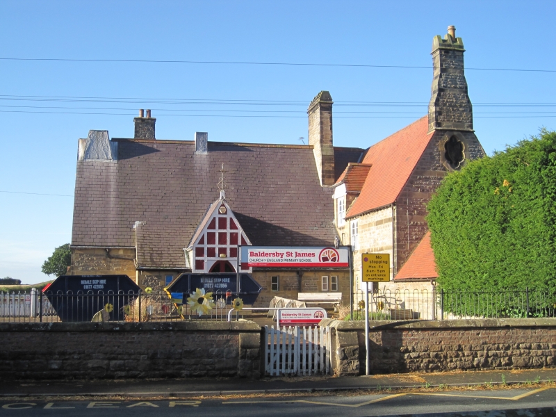
SE 37 NE BALDERSBY WIDE HOWE LANE
(south side)
Baldersby St James
3/29 School and School
26.5.71 House
-
GV II*
School and house. 1854. By William Butterfield for Viscount Downe of
Baldersby Park. Snecked stone with ashlar bands and window surrounds.
Westmorland slate roof to school, tiles on house, stone stacks. School:
L-shaped 2-room plan with school house attached to right. High
Victorian style, one and a half storeys, irregular fenestration.
Central panelled door under timber-framed gabled porch with lean-to roof
on each side. Main hall lit by two 2-light Geometric windows in left
gable. Stack straddling roof has flues in the form of truncated
pyramids. School house: I and one and a half storeys, 5 bays. Central
door under wooden porch with barge boards. Flanking windows are 3-light
mullions with wooden sashes. Two 2-light mullion windows under half-
hipped dormers above. Roof: hipped to right; shield of Downe family in
recess to left gable. Single-storey bay to left has a hipped roof.
Stack at left gable end has flues in the form of truncated pyramids.
Interior: original wooden staircase with open wooden screen at the foot.
Large linen cupboard on landing.
Listing NGR: SE3658676883
External links are from the relevant listing authority and, where applicable, Wikidata. Wikidata IDs may be related buildings as well as this specific building. If you want to add or update a link, you will need to do so by editing the Wikidata entry.


Other nearby listed buildings
