Approximate Location Map
Large Map »
Latitude: 51.4391 / 51°26'20"N
Longitude: -2.8644 / 2°51'51"W
OS Eastings: 340016
OS Northings: 171482
OS Grid: ST400714
Mapcode National: GBR JC.NG7M
Mapcode Global: VH7C7.93L2
Plus Code: 9C3VC4QP+M7
Entry Name: Bandstand on Green Beach
Listing Date: 22 January 1976
Grade: II
Source: Historic England
Source ID: 1129709
English Heritage Legacy ID: 33059
ID on this website: 101129709
Location: Salthouse Fields, Clevedon, North Somerset, BS21
County: North Somerset
Civil Parish: Clevedon
Built-Up Area: Clevedon
Traditional County: Somerset
Lieutenancy Area (Ceremonial County): Somerset
Tagged with: Bandstand
1. ELTON ROAD
5121
(West Side)
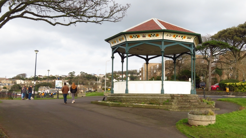
Bandstand on Green Beach
ST 4071 1/57
II
2.
On open ground overlooking the sea shore. Dated 1887. Octagonal openwork wooden
structure with pyramidal tile roof. Coved eaves with painted boards showing
sunflowers and musical instruments. Circular metal columns with foliage capitals
and braces support the roof. Boarded front to platform rests on a rusticated
stone plinth.
Listing NGR: ST4001671482
External links are from the relevant listing authority and, where applicable, Wikidata. Wikidata IDs may be related buildings as well as this specific building. If you want to add or update a link, you will need to do so by editing the Wikidata entry.


Other nearby listed buildings
