Approximate Location Map
Large Map »
Latitude: 51.4394 / 51°26'21"N
Longitude: -2.8514 / 2°51'5"W
OS Eastings: 340916
OS Northings: 171496
OS Grid: ST409714
Mapcode National: GBR JC.NKH6
Mapcode Global: VH7C7.J2FX
Plus Code: 9C3VC4QX+PC
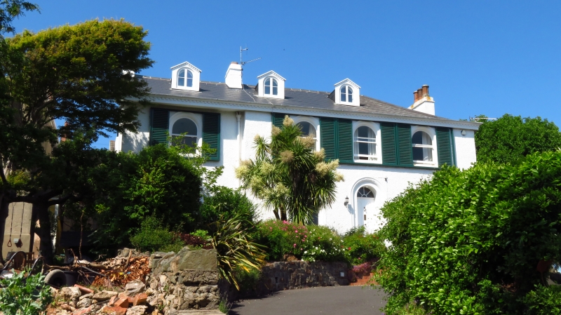
Entry Name: The White House
Listing Date: 22 January 1976
Grade: II
Source: Historic England
Source ID: 1200350
English Heritage Legacy ID: 33067
ID on this website: 101200350
Location: Clevedon, North Somerset, BS21
County: North Somerset
Civil Parish: Clevedon
Built-Up Area: Clevedon
Traditional County: Somerset
Lieutenancy Area (Ceremonial County): Somerset
Tagged with: House
HIGHDAIE ROAD
1.
5121
(North Side)
The White House
ST 4071 1/62
II GV
2.
2 storey mid C19 villa, now altered. Left end is set back. Slate roof with
3 gabled dormers. Dentil cornice. 4 windows in round-headed arches with architrave
surrounds. Sashes without glazing bars. Doorway with similar surround. Included
for group value only.
No 5, the White House, Nos 11 to 15 (odd), Woodspring District offices, and
Christ Church Chapel Hill form a group.
Listing NGR: ST4091671496
External links are from the relevant listing authority and, where applicable, Wikidata. Wikidata IDs may be related buildings as well as this specific building. If you want to add or update a link, you will need to do so by editing the Wikidata entry.


Other nearby listed buildings
