Approximate Location Map
Large Map »
Latitude: 54.0107 / 54°0'38"N
Longitude: -1.4785 / 1°28'42"W
OS Eastings: 434276
OS Northings: 457312
OS Grid: SE342573
Mapcode National: GBR LQ32.Q0
Mapcode Global: WHD9L.8G75
Plus Code: 9C6W2G6C+7J
Entry Name: Gate, Gate Piers and Flanking Walls Approximately 80 Metres to South of Conyngham Hall
Listing Date: 12 December 1985
Grade: II
Source: Historic England
Source ID: 1188712
English Heritage Legacy ID: 330726
ID on this website: 101188712
Location: Tentergate, North Yorkshire, HG5
County: North Yorkshire
District: Harrogate
Civil Parish: Knaresborough
Traditional County: Yorkshire
Lieutenancy Area (Ceremonial County): North Yorkshire
Church of England Parish: Knaresborough
Church of England Diocese: Leeds
Tagged with: Gate
SE 3457 KNARESBOROUGH BOND END
(west side, off)
6/63 Gates, gate piers and
flanking walls
approximately 80 metres
to south of Conyngham
Hall (q.v.)
GV II
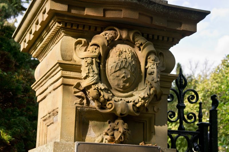
Gates, gate piers and flanking walls. Late C18 or mid C19. Wrought-iron
gates, ashlar piers and walls. Double gates, approximately 2.5 metres high
at centre and ramped down to short railings fastened to piers, have spear-
headed dog-bars, elaborate C and S scrolls and monogram 'E C C' in centre of
each leaf. Gate piers: square in section, approximately 3 metres high, with
plinths, 3 projecting bands to each shaft, wreathed shield, cornice and ball
finial. Flanking walls: approximately 1.2 metres high, curving towards
house with plinth, shallow gabled coping, C-scrolls against gate piers, and
end piers with ball finials. The house (q.v.) was originally Coghill Hall;
the name was changed when it was bought by Ellen, Countess of Conyngham in
1796, who restored and enlarged it. The monogram on the gates is probably
hers, but the piers may date from a second major phase of rebuilding in
1856.
H Speight, Nidderdale, 1894, p 312.
Listing NGR: SE3427657312
External links are from the relevant listing authority and, where applicable, Wikidata. Wikidata IDs may be related buildings as well as this specific building. If you want to add or update a link, you will need to do so by editing the Wikidata entry.


Other nearby listed buildings
