Approximate Location Map
Large Map »
Latitude: 51.4402 / 51°26'24"N
Longitude: -2.8531 / 2°51'11"W
OS Eastings: 340802
OS Northings: 171595
OS Grid: ST408715
Mapcode National: GBR JC.NK1R
Mapcode Global: VH7C7.H2K7
Plus Code: 9C3VC4RW+3Q
Entry Name: 17 and 17A, Hill Road
Listing Date: 22 January 1976
Grade: II
Source: Historic England
Source ID: 1136386
English Heritage Legacy ID: 33081
ID on this website: 101136386
Location: Clevedon, North Somerset, BS21
County: North Somerset
Civil Parish: Clevedon
Built-Up Area: Clevedon
Traditional County: Somerset
Lieutenancy Area (Ceremonial County): Somerset
Tagged with: Building
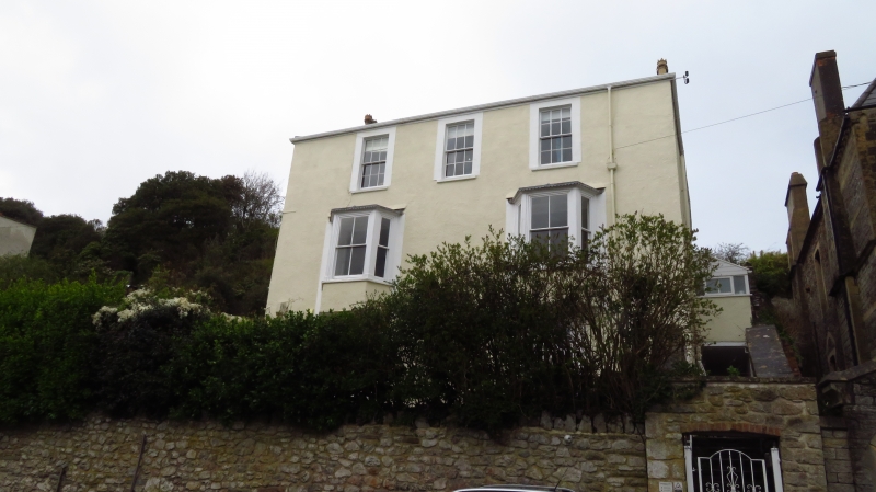
HILL ROAD
5121
(North East Side)
Nos 17 and 17A
ST 4071 1/73
II GV
2.
3 storey roughcast front, probably mid C19 with alterations. Hipped slate roof.
3 windows with plain surrounds to 2nd floor. Two 3-light canted bays project
over ground floor windows. Sashes with glazing bars to 2nd and ground floors.
Entrance in side. Included for group value only.
Nos 5 to 17 (odd), 17a, 19 and 21 form a group.
Listing NGR: ST4080271595
External links are from the relevant listing authority and, where applicable, Wikidata. Wikidata IDs may be related buildings as well as this specific building. If you want to add or update a link, you will need to do so by editing the Wikidata entry.


Other nearby listed buildings
