Approximate Location Map
Large Map »
Latitude: 54.01 / 54°0'35"N
Longitude: -1.4694 / 1°28'9"W
OS Eastings: 434872
OS Northings: 457238
OS Grid: SE348572
Mapcode National: GBR LQ52.P8
Mapcode Global: WHD9L.DGJQ
Plus Code: 9C6W2G5J+X7
Entry Name: The Old School House
Listing Date: 15 May 1968
Grade: II
Source: Historic England
Source ID: 1293752
English Heritage Legacy ID: 330812
ID on this website: 101293752
Location: Knaresborough, North Yorkshire, HG5
County: North Yorkshire
District: Harrogate
Civil Parish: Knaresborough
Built-Up Area: Knaresborough
Traditional County: Yorkshire
Lieutenancy Area (Ceremonial County): North Yorkshire
Church of England Parish: Knaresborough
Church of England Diocese: Leeds
Tagged with: House
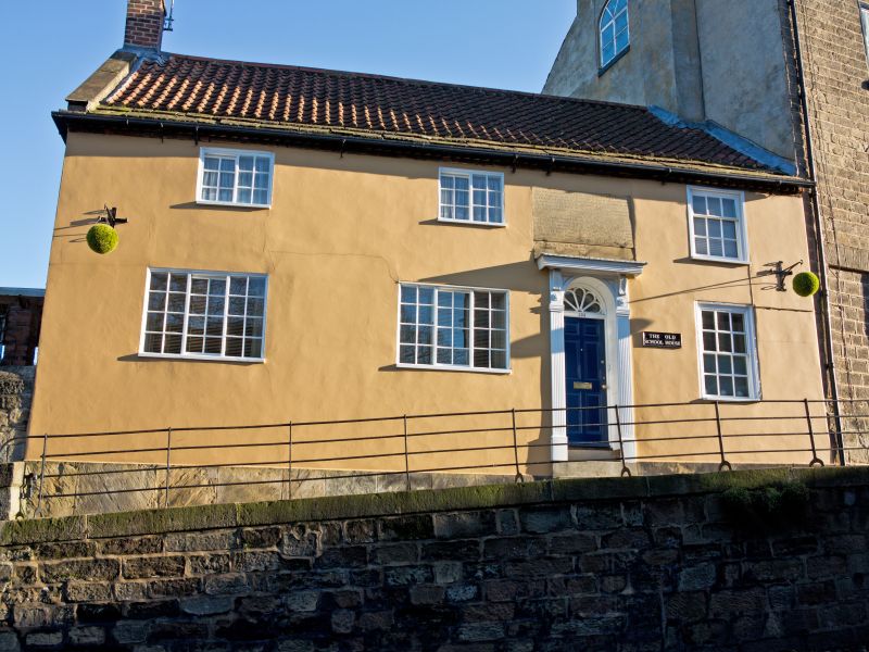
SE 3457 KNARESBOROUGH HIGH STREET
(north side)
6/143 No 102 (The Old School
House)
15.5.68
GV II
School house, now house. Mid C18 with C20 restoration. Rendered, pantile
roof with 3 eaves cornices of stone slates. 2 storeys, 3 first-floor
windows. 6-panel door to right of centre, with fanlight, panelled reveals
and wooden doorcase, (erected since 1968). Large stone tablet above. To
right, sash with glazing bars in flush wood architrave with 9-pane unequally
hung sash above. To left, two 3-light side-sliding sashes with 24 panes,
with two 2-light side-sliding sashes with glazing bars above. Ashlar gable
coping and end stack of brick to left. The tablet above the door carries an
inscription listing the donors and date of the school. Thomas Richardson
gave this burgage house and £400 in trust to found an elementary school in
1765. It was know as Richardson's or the Charity School. By 1826 the
donations had totalled £2,139 and 30 children were admitted. E Hargrove,
History of the Castle, Town and Forest of Knaresborough, 6th Edition, 1809,
p80. B Jennings, Harrogate and Knaresborough, 1970, p379.
Listing NGR: SE3487257238
External links are from the relevant listing authority and, where applicable, Wikidata. Wikidata IDs may be related buildings as well as this specific building. If you want to add or update a link, you will need to do so by editing the Wikidata entry.


Other nearby listed buildings
