Approximate Location Map
Large Map »
Latitude: 51.4423 / 51°26'32"N
Longitude: -2.8561 / 2°51'21"W
OS Eastings: 340596
OS Northings: 171829
OS Grid: ST405718
Mapcode National: GBR JC.NB9S
Mapcode Global: VH7C7.F0YM
Plus Code: 9C3VC4RV+WH
Entry Name: Hill House
Listing Date: 22 January 1976
Grade: II
Source: Historic England
Source ID: 1312806
English Heritage Legacy ID: 33089
ID on this website: 101312806
Location: Clevedon, North Somerset, BS21
County: North Somerset
Civil Parish: Clevedon
Built-Up Area: Clevedon
Traditional County: Somerset
Lieutenancy Area (Ceremonial County): Somerset
Tagged with: House
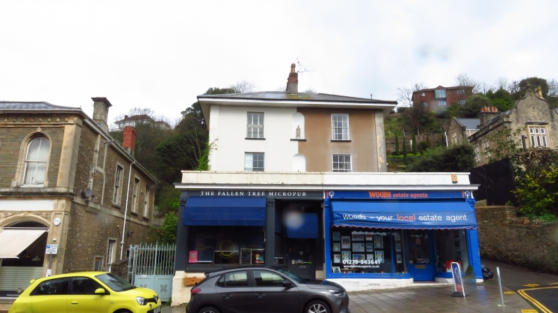
HILL ROAD
1.
5121
(North East Side)
No 41 (Hill House)
and No 43
ST 4071 1/79
II GV
2.
Tall 3 storey early/mid C19 house on corner with Zig Zag path. Ground floor
obscured by shops on street. Roughcast front. Hipped slate roof with projecting
eaves. End pilasters. 2 windows per storey with painted niche in centre. Sashes
with glazing bars. Entrances in sides. C19 shop fronts with pilasters and capitals.
Nos 39 to 43 (odd) form a group.
Listing NGR: ST4059671829
External links are from the relevant listing authority and, where applicable, Wikidata. Wikidata IDs may be related buildings as well as this specific building. If you want to add or update a link, you will need to do so by editing the Wikidata entry.


Other nearby listed buildings
