Approximate Location Map
Large Map »
Latitude: 54.0881 / 54°5'17"N
Longitude: -1.7688 / 1°46'7"W
OS Eastings: 415218
OS Northings: 465828
OS Grid: SE152658
Mapcode National: GBR JP25.V8
Mapcode Global: WHC7X.SHWT
Plus Code: 9C6W36QJ+7F
Entry Name: Grassfield House Hotel
Listing Date: 3 March 1987
Grade: II
Source: Historic England
Source ID: 1150595
English Heritage Legacy ID: 331144
ID on this website: 101150595
Location: Bridgehouse Gate, North Yorkshire, HG3
County: North Yorkshire
District: Harrogate
Civil Parish: Bewerley
Built-Up Area: Pateley Bridge
Traditional County: Yorkshire
Lieutenancy Area (Ceremonial County): North Yorkshire
Tagged with: Hotel
BEWERLEY RAMSGILL ROAD
SE 16 NE (west side)
3/16 Grassfield House Hotel
- II
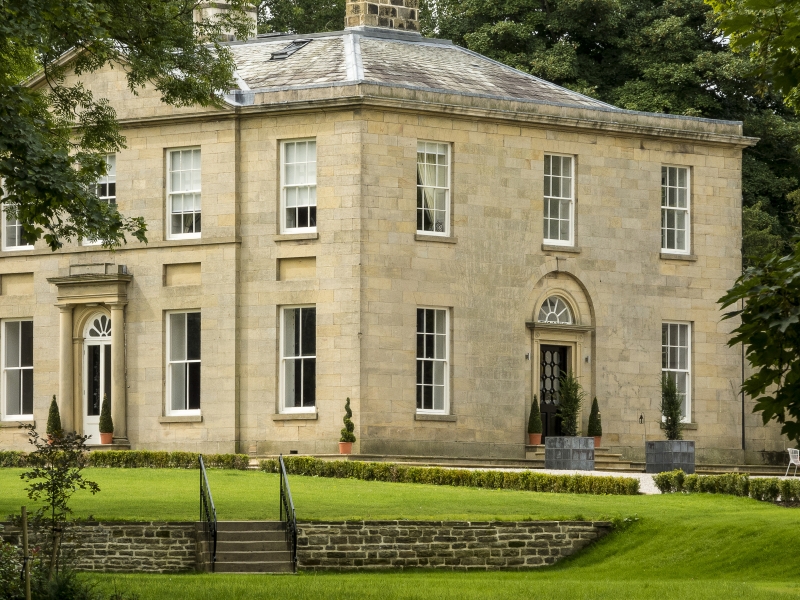
House, now hotel. 1810. For Hanley Hutchinson. Ashlar, grey slate roof.
2-storey, 5-bay main block, the central 3 bays pedimented and breaking
forward; 3 bays deep. Attached range to left adjoins rear of building, of 2
storeys and 2 bays with later 2-storey, l-bay addition to left. Wall
attached to rear right continues to right, ramps down to gate piers and
continues for approximately 10 metres. Main block: central glazed double
door with fanlight in moulded architrave with imposts; flanking Doric
columns support entablature, cornice and blocking course. Flanking windows,
ground floor: 4-pane sashes with projecting sills and incised lintels.
First floor: sashes with glazing bars, sill band to central 3 bays, lintels
as ground floor. Rectangular recesses between ground and first-floor
windows. Moulded eaves and pediment cornice. Hipped roof with paired
stacks to bays 2 and 4. Attached range to left: two 16-pane sashes to
ground floor, sashes with glazing bars above. Architectural details as main
facade. Left bay not of special interest. Wall attached to right: 2 blind
windows with rectangular panels above; moulded cornice and blocking course.
To right: ramped wall of coursed squared rubble with flat coping; lean-to
garden house attached to north side with 3 blocked round arched windows with
keystones, gable coping and bulbous kneelers. Gate piers approximately 3
metres high: plinths, cornices and pyramidal finials. Wall continues for
approximately 10 metres to right, ramped down once. Hanley Hutchinson was a
leading figure in the Greenhow lead mining industry in the area. He leased
the Cockhill-Sunside lead mines from the Yorke family and was a member of
the provisional committee of the Yorkshire and Lancashire railway in the
1840's. He owned the Brigg House Rolling Mill where sheet lead and lead
pipes were manufactured. W Grainge, Nidderdale, (1863), p 65. B Jennings,
A History of Nidderdale (1967), pp 201, 295, 341.
Listing NGR: SE1521865828
External links are from the relevant listing authority and, where applicable, Wikidata. Wikidata IDs may be related buildings as well as this specific building. If you want to add or update a link, you will need to do so by editing the Wikidata entry.


Other nearby listed buildings
