Approximate Location Map
Large Map »
Latitude: 54.0381 / 54°2'17"N
Longitude: -1.6415 / 1°38'29"W
OS Eastings: 423573
OS Northings: 460294
OS Grid: SE235602
Mapcode National: GBR JPZR.D6
Mapcode Global: WHC85.RRHP
Plus Code: 9C6W29Q5+69
Entry Name: New Bridge
Listing Date: 6 March 1967
Grade: II
Source: Historic England
Source ID: 1150597
English Heritage Legacy ID: 331149
ID on this website: 101150597
Location: Birstwith, North Yorkshire, HG3
County: North Yorkshire
District: Harrogate
Civil Parish: Birstwith
Traditional County: Yorkshire
Lieutenancy Area (Ceremonial County): North Yorkshire
Church of England Parish: Birstwith St James
Church of England Diocese: Leeds
BIRSTWITH DARLEY ROAD
SE 26 SW (north side, off)
9/21 New Bridge
6.3.67
GV II
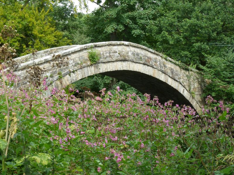
Bridge over River Nidd. 1822, possibly reusing earlier materials. Coursed
squared gritstone, of sandy texture on north-west (upstream) side and harder
greyer stone on south-east; paved with river cobbles. A single high round
arch carries the 2-metre wide causeway over a span of approximately 20
metres. Voussoirs and projecting band, rounded parapet coping; the parapet
terminates in square bollards with pyramidal caps. At each end the width of
the path is narrowed by a pair of stone bollards approximately
60 centimetres high, rounded and with grooved surfaces. 2 iron loops are
built into the parapet outer surface on the upstream side. A stone stile is
built into the parapet wall, south-west end. The bridge stands on the pack-
horse track from Otley to Ripon. The earlier single-span bridge which stood
about 25 yards upstream was demolished in 1822; it is likely that this
bridge has reused stone from it and is of a similar style. A Scheduled
Ancient Monument. H Speight, Nidderdale, 1894, p 398.
Listing NGR: SE2357360293
External links are from the relevant listing authority and, where applicable, Wikidata. Wikidata IDs may be related buildings as well as this specific building. If you want to add or update a link, you will need to do so by editing the Wikidata entry.


Other nearby listed buildings
