Approximate Location Map
Large Map »
Latitude: 54.1053 / 54°6'18"N
Longitude: -1.7804 / 1°46'49"W
OS Eastings: 414457
OS Northings: 467732
OS Grid: SE144677
Mapcode National: GBR JN0Z.B4
Mapcode Global: WHC7X.M2DN
Plus Code: 9C6W4649+4R
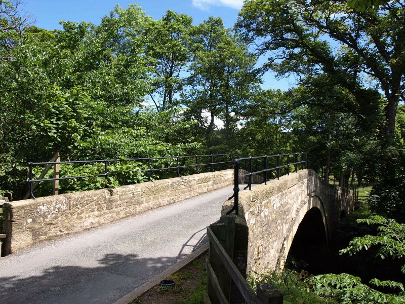
Entry Name: Wath Bridge
Listing Date: 25 June 1987
Grade: II
Source: Historic England
Source ID: 1150530
English Heritage Legacy ID: 331291
ID on this website: 101150530
Location: Wath, North Yorkshire, HG3
County: North Yorkshire
District: Harrogate
Civil Parish: Fountains Earth
Traditional County: Yorkshire
Lieutenancy Area (Ceremonial County): North Yorkshire
Tagged with: Bridge
FOUNTAINS EARTH WATH
SE 16 NW
12/11 Wath Bridge
- II
Bridge. Early C19. Coursed squared stone and ashlar. Single segmental
arch with voussoirs and hoodmould, coped parapet with iron railings. This
bridge is also in the parishes of High and Low Bishopside and Stonebeck Down.
Listing NGR: SE1445767732
External links are from the relevant listing authority and, where applicable, Wikidata. Wikidata IDs may be related buildings as well as this specific building. If you want to add or update a link, you will need to do so by editing the Wikidata entry.


Other nearby listed buildings
