Approximate Location Map
Large Map »
Latitude: 54.1904 / 54°11'25"N
Longitude: -1.6455 / 1°38'43"W
OS Eastings: 423231
OS Northings: 477234
OS Grid: SE232772
Mapcode National: GBR JMYZ.KM
Mapcode Global: WHC7D.PXNZ
Plus Code: 9C6W59R3+4R
Entry Name: The Ruin, Mowbray Point
Listing Date: 25 June 1987
Grade: II*
Source: Historic England
Source ID: 1150534
English Heritage Legacy ID: 331303
Also known as: The Ruin
ID on this website: 101150534
Location: Wapping, North Yorkshire, HG4
County: North Yorkshire
District: Harrogate
Civil Parish: Grewelthorpe
Traditional County: Yorkshire
Lieutenancy Area (Ceremonial County): North Yorkshire
Church of England Parish: Grewelthorpe St James
Church of England Diocese: Leeds
Tagged with: Architectural structure
This list entry was subject to a Minor Amendment on 27/01/2012
1435/5/23
02-SEP-03
GREWELTHORPE
HACKFALL
THE RUIN, MOWBRAY POINT
(Formerly listed as Mowbray Point)
II*
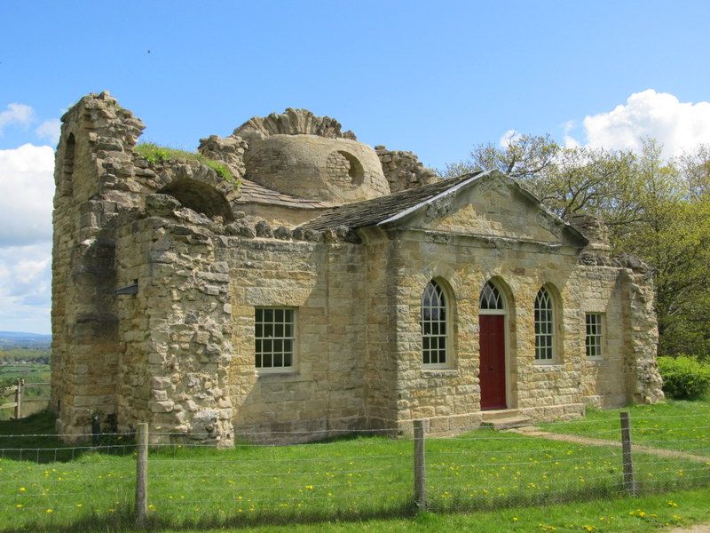
Folly/banqueting house. Circa 1750 built by Mr Wood for Wm Aislabie. Ashlar, tufa and rubblestone. 1 storey, 5 bays. Central 3 bays break forward under a pediment. Central doorway with pointed arch, flanked by pointed-arched openings, all with voussoirs. Pediment has moulded cornice, of ashlar and tufa. Outer bays have rectangular openings with remains of wide rubble walls to outer side of each bay.
Rear elevation: possibly a slightly later addition, designed in imitation of a ruined Roman Bath, possibly designed by Robert Adam. 3 bays, tall round-arched openings, the central opening being the tallest, semicircular in plan with half dome roof pierced with 3 roundels. Outer bays are tunnel vaulted with round-headed niches to each side with lunette niches above them.
INTERIOR: the front part of the building has remains of ogee-headed niches with wooden architraves. Derelict at time of resurvey.
See Fishers Hall, Hackfall item 5/21 for History. North Yorkshire Historic Gardens Register - Hackfall, Grade I.
Listing NGR: SE2323177234
External links are from the relevant listing authority and, where applicable, Wikidata. Wikidata IDs may be related buildings as well as this specific building. If you want to add or update a link, you will need to do so by editing the Wikidata entry.


Other nearby listed buildings
