Approximate Location Map
Large Map »
Latitude: 54.3688 / 54°22'7"N
Longitude: -1.3015 / 1°18'5"W
OS Eastings: 445478
OS Northings: 497260
OS Grid: SE454972
Mapcode National: GBR MKCX.0N
Mapcode Global: WHD7X.ZGD4
Plus Code: 9C6W9M9X+G9
Entry Name: 30, West End
Listing Date: 31 March 1970
Last Amended: 12 November 1987
Grade: II
Source: Historic England
Source ID: 1188782
English Heritage Legacy ID: 332498
ID on this website: 101188782
Location: Osmotherley, North Yorkshire, DL6
County: North Yorkshire
District: Hambleton
Civil Parish: Osmotherley
Built-Up Area: Osmotherley
Traditional County: Yorkshire
Lieutenancy Area (Ceremonial County): North Yorkshire
Church of England Parish: Osmotherley St Peter
Church of England Diocese: York
Tagged with: Building
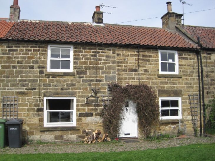
OSMOTHERLEY WEST END
SE 4497-4597
(north side)
6/95 No 30
(formerly listed as
31.3.70 30 Main Street)
GV II
House. Early C19. Ashlar, pantile roof. 2 storeys, 2 bays. Door to rear.
Ground floor has 4-pane casements. First floor has 4-pane sashes. All
windows have stone sills. 2 ridge stacks. Included for group value.
Listing NGR: SE4547897260
External links are from the relevant listing authority and, where applicable, Wikidata. Wikidata IDs may be related buildings as well as this specific building. If you want to add or update a link, you will need to do so by editing the Wikidata entry.


Other nearby listed buildings
