Approximate Location Map
Large Map »
Latitude: 54.3021 / 54°18'7"N
Longitude: -1.2852 / 1°17'6"W
OS Eastings: 446613
OS Northings: 489843
OS Grid: SE466898
Mapcode National: GBR MLGP.KL
Mapcode Global: WHD8B.7489
Plus Code: 9C6W8P27+RW
Entry Name: The Almhouses
Listing Date: 1 May 1952
Grade: II
Source: Historic England
Source ID: 1190826
English Heritage Legacy ID: 332544
ID on this website: 101190826
Location: Cowesby, North Yorkshire, YO7
County: North Yorkshire
District: Hambleton
Civil Parish: Cowesby
Traditional County: Yorkshire
Lieutenancy Area (Ceremonial County): North Yorkshire
Tagged with: Almshouse
COWESBY MAIN STREET
SE 4689
(EAST SIDE, OFF)
9/17 THE ALMSHOUSES
1.5.52
GV II
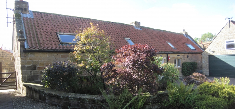
Row of 4 almshouses, now one dwelling. Late C17 for Nathaniel, Lord Crewe,
Bishop of Durham; coverted c1980. Tooled coursed squared stone, pantile roof.
Single-storey with attic, 4 cells. Plinth. Two sets of paired chamfered
quoined doorways with triangular soffits to lintels flanked by 2-tight recessed
chamfered mullion windows. Ashlar coping on shaped kneelers with ball finials.
Rebuilt end and central ridge stacks. Rear: a single-tight recessed chamfered
window to each cell, the 2nd from right enlarged to a 2-light window; inserted
central door and skylights. Each return has two recessed chamfered tights to
gables. Interior: chamfered and stop-chamfered spine beams. End fireplaces
with adjacent stone spiral staircases survive, that at right end plastered over,
that at left end with chamfered surround and massive 2-piece lintel. Attic:
large-scantling purlins. The attics of the central almshouses were formerly lit
by dormers and the stacks were corniced (pre-conversion photo held by owner).
The roof originally had coupled common rafters with occasional collars (WYCVBSG
Report). The building has been dated dendrochronologically to 1680+ 9 years
(ibid). -
W. Grainge, The Vale of Mowbray: a historical and topographical account of
Thirsk and its Neighbourhood (1859). North Yorkshire and Cleveland Vernacular
Buildings Study Group, Report No. 685.
Listing NGR: SE4661389843
External links are from the relevant listing authority and, where applicable, Wikidata. Wikidata IDs may be related buildings as well as this specific building. If you want to add or update a link, you will need to do so by editing the Wikidata entry.


Other nearby listed buildings
