Approximate Location Map
Large Map »
Latitude: 54.2087 / 54°12'31"N
Longitude: -1.5528 / 1°33'10"W
OS Eastings: 429263
OS Northings: 479312
OS Grid: SE292793
Mapcode National: GBR KMLS.M1
Mapcode Global: WHC7G.3GTW
Plus Code: 9C6W6C5W+FV
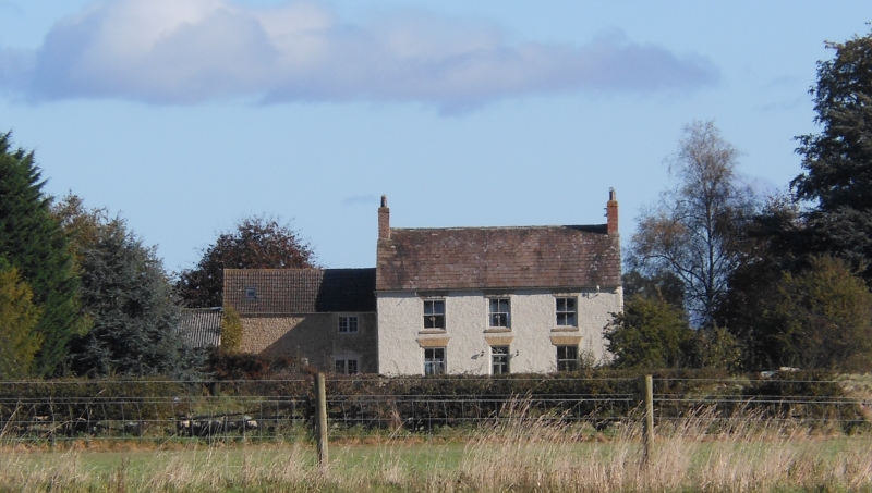
Entry Name: Chapel Hill Farmhouse
Listing Date: 30 August 1988
Grade: II
Source: Historic England
Source ID: 1150803
English Heritage Legacy ID: 332647
ID on this website: 101150803
Location: Thornborough, North Yorkshire, DL8
County: North Yorkshire
District: Hambleton
Civil Parish: East Tanfield
Traditional County: Yorkshire
Lieutenancy Area (Ceremonial County): North Yorkshire
Tagged with: Farmhouse
EAST TANFIELD THORNBOROUGH ROAD
SE 27 NE
(south side, off)
8/16 Chapel Hill Farmhouse
- II
Farmhouse. Early C19. Render with painted stone dressings. Graduated
stone slate roof. 2 storeys, 3 bays, symmetrical facade. Central C20 6-
panel door and overlight with radial glazing bars below flat arch with
incised voussoirs. All windows are 4-pane sashes with stone sills and flat
arches with incised voussoirs. Brick end stacks.
Listing NGR: SE2926379312
External links are from the relevant listing authority and, where applicable, Wikidata. Wikidata IDs may be related buildings as well as this specific building. If you want to add or update a link, you will need to do so by editing the Wikidata entry.


Other nearby listed buildings
