Approximate Location Map
Large Map »
Latitude: 54.4575 / 54°27'27"N
Longitude: -1.2619 / 1°15'42"W
OS Eastings: 447949
OS Northings: 507154
OS Grid: NZ479071
Mapcode National: GBR MJMW.LW
Mapcode Global: WHD7K.L794
Plus Code: 9C6WFP5Q+26
Entry Name: North Lodge and Gateway
Listing Date: 8 May 1989
Grade: II
Source: Historic England
Source ID: 1294276
English Heritage Legacy ID: 333047
ID on this website: 101294276
Location: Skutterskelfe, North Yorkshire, TS15
County: North Yorkshire
District: Hambleton
Civil Parish: Skutterskelfe
Traditional County: Yorkshire
Lieutenancy Area (Ceremonial County): North Yorkshire
Church of England Parish: Rudby-in-Cleveland All Saints
Church of England Diocese: York
Tagged with: Building
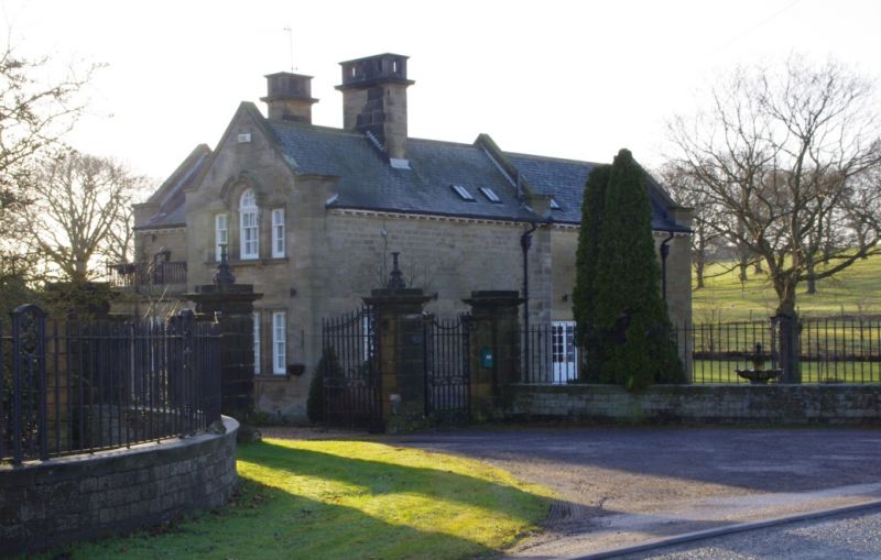
SKUTTERSKELFE SKUTTERSKELFE PARK
NZ 40 NE
5/119 North Lodge and gateway
- II
Former lodge to %Skutterskelfe hall, with gates, piers, walls and raling. Circa
1900. Lodge tooled ashlar with green slate roof, walls and piers ashlar, gates
and railings wrought iron. Lodge T-plan, gateway semi-circular Baroque style.
Lodge 1½ storeys, 2 bays to road, irregular. Panelled door with overlight;
in quasi-Ionic doorcase, in extruded porch with iron balustrade above. 3 sashes
in rebated reveals on road front ground floor; upper storey blank. On left
return gable end a Venetian window in architrave with keyed deep segmental hood
on console brackets; projecting cill. 3 grouped windows in architraves below.
All window sashes with glazing bars. Gateway consists of 4 rusticated piers,
with plinth, cornice and block course, supporting 1 double and 2 single wrought-
iron gates; iron lamp standards on inner piers. Flanking convex quadrant walls
have wrought iron railings, with ornamental panels at intervals, and lead to
2 pairs of outer piers, similar but with no gates. Lodge is now in different
ownership and separated from the Hall by a road.
Listing NGR: NZ4794907154
External links are from the relevant listing authority and, where applicable, Wikidata. Wikidata IDs may be related buildings as well as this specific building. If you want to add or update a link, you will need to do so by editing the Wikidata entry.


Other nearby listed buildings
