Approximate Location Map
Large Map »
Latitude: 54.2891 / 54°17'20"N
Longitude: -1.5932 / 1°35'35"W
OS Eastings: 426579
OS Northings: 488241
OS Grid: SE265882
Mapcode National: GBR KL9V.W7
Mapcode Global: WHC71.HGK7
Plus Code: 9C6W7CQ4+JP
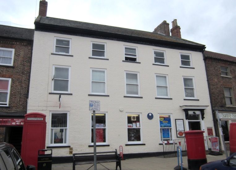
Entry Name: The Post Office
Listing Date: 31 July 1970
Grade: II
Source: Historic England
Source ID: 1189685
English Heritage Legacy ID: 333525
ID on this website: 101189685
Location: Bedale, North Yorkshire, DL8
County: North Yorkshire
District: Hambleton
Civil Parish: Bedale
Built-Up Area: Bedale
Traditional County: Yorkshire
Lieutenancy Area (Ceremonial County): North Yorkshire
Tagged with: Post office
BEDALE MARKET PLACE
SE 2688-2788 (west side)
No 6 (The Post Office)
8/17
31.7.70
GV II
House now Post Office. Early to mid C18. Red brick in Flemish bond with
graduated slate roof. 3 storeys, 5 bays. Plinth. Early C20 4-panel door
with overlight in surround with pilasters, consoles, frieze and cornice.
All windows are sashes with flat brick arches and stone cills. Stepped
dentilled eaves. Stone coping. End stacks.
Listing NGR: SE2657388232
External links are from the relevant listing authority and, where applicable, Wikidata. Wikidata IDs may be related buildings as well as this specific building. If you want to add or update a link, you will need to do so by editing the Wikidata entry.


Other nearby listed buildings
