Approximate Location Map
Large Map »
Latitude: 53.5364 / 53°32'11"N
Longitude: -1.4851 / 1°29'6"W
OS Eastings: 434222
OS Northings: 404539
OS Grid: SE342045
Mapcode National: GBR LW2K.80
Mapcode Global: WHDCX.5C2S
Plus Code: 9C5WGGP7+HX
Entry Name: L shaped range of farmbuildings immediately to east of Ouslethwaite Hall including Ouslethwaite Cottage
Listing Date: 4 December 1986
Grade: II
Source: Historic England
Source ID: 1315078
English Heritage Legacy ID: 333954
ID on this website: 101315078
Location: Ward Green, Barnsley, South Yorkshire, S70
County: Barnsley
Electoral Ward/Division: Worsbrough
Parish: Non Civil Parish
Traditional County: Yorkshire
Lieutenancy Area (Ceremonial County): South Yorkshire
Church of England Parish: Worsbrough Common St Luke
Church of England Diocese: Sheffield
Tagged with: Cottage
This list entry was subject to a Minor Amendment on 1 November 2021 to reformat text to current standards
SE30SW
1/83
WORSBROUGH
GENN LANE (north side)
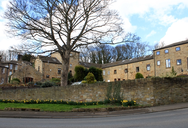
L-shaped range of farmbuildings immediately to east of Ouslethwaite Hall including Ouslethwaite Cottage
GV
II
Farmbuildings including stable-block with; dovecote and cottage. Late C18-early C19. Deeply-coursed dressed sandstone, stone slate and sheet asbestos roofs. L-shaped plan mostly of two storeys, dovecote in four-storey tower. Side facing Ouslethwaite Hall (q.v.): large quoins. Archway to left of centre has cottage on its left with tripartite sash beneath casement with lintel tooled as voussoirs; two-light horizontally-sliding sash over arch. To right of arch are external steps with dog kennel under and iron handrail, quoined first-floor door with two casements to its left. Tower on right has segmental-arched carriage entrance on left of quoined doorway, casements in square-faced surrounds to first and second floors, blind lunette to third floor and hipped roof with louvred lantern. To right of tower is a quoined doorway to left or tall casement with one large and one small window over. Shaped kneelers and ashlar gable copings to right end of range.
Rear: side wall of wing terminates in taller part with two infilled segmental arches to ground floor and arched first-floor doorway, hipped stone slate roof.
Attached cottages to rear of this part not of special interest.
Listing NGR: SE3422204539
External links are from the relevant listing authority and, where applicable, Wikidata. Wikidata IDs may be related buildings as well as this specific building. If you want to add or update a link, you will need to do so by editing the Wikidata entry.


Other nearby listed buildings
