Approximate Location Map
Large Map »
Latitude: 53.5311 / 53°31'51"N
Longitude: -1.631 / 1°37'51"W
OS Eastings: 424553
OS Northings: 403890
OS Grid: SE245038
Mapcode National: GBR KW1L.PX
Mapcode Global: WHCBP.XHHV
Plus Code: 9C5WG9J9+CH
Entry Name: Barn approximately 10 metres east of Nether Mill House
Listing Date: 23 June 1965
Grade: II
Source: Historic England
Source ID: 1315071
English Heritage Legacy ID: 334031
ID on this website: 101315071
Location: Bridge End, Barnsley, South Yorkshire, S36
County: Barnsley
Civil Parish: Penistone
Built-Up Area: Penistone
Traditional County: Yorkshire
Lieutenancy Area (Ceremonial County): South Yorkshire
Church of England Parish: Penistone St John the Baptist
Church of England Diocese: Sheffield
Tagged with: Barn
This list entry was subject to a Minor Amendment on 25 October 2021 to reformat text to current standards
SE20SW
3/6
PENISTONE
BARNSLEY ROAD (north side)
Barn approximately 10 metres east of Nether Mill House
23/06/1965
GV
II
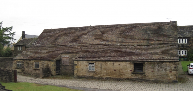
Barn. Cruck frame probably C16, encased in C17 or C18 with C19 restoration and alterations. Coursed-squared rubble of several build. Stone slate roof. Five internal bays, with outshuts to front. Former cart entrance to right part of bay two now extended forward and part-blocked. C19 window openings to outshuts. Opposing, part-blocked, cart-entry to rear with segmental head (C19).
Interior: three crook trusses with collars and extended tie-beams. Trusses one and two have the front blades truncated at tie-beam level and are supported on a pier and a wall respectively which was presumably done at the time the outshuts were built. Reverse-curved braces from blades to purlins. Truss three is infilled with a random selection of studs and braces. A fourth truss with deep cambered tie-bead and softwood king post and principal rafters probably indicate that the barn has been extended to the right.
Listing NGR: SE2455303890
External links are from the relevant listing authority and, where applicable, Wikidata. Wikidata IDs may be related buildings as well as this specific building. If you want to add or update a link, you will need to do so by editing the Wikidata entry.


Other nearby listed buildings
