Approximate Location Map
Large Map »
Latitude: 53.4332 / 53°25'59"N
Longitude: -1.1082 / 1°6'29"W
OS Eastings: 459346
OS Northings: 393302
OS Grid: SK593933
Mapcode National: GBR NXPR.W0
Mapcode Global: WHDDG.YYGY
Plus Code: 9C5WCVMR+7P
Entry Name: The Vicarage
Listing Date: 22 January 1981
Grade: II
Source: Historic England
Source ID: 1314766
English Heritage Legacy ID: 334381
ID on this website: 101314766
Location: Tickhill, Doncaster, South Yorkshire, DN11
County: Doncaster
Civil Parish: Tickhill
Built-Up Area: Tickhill
Traditional County: Yorkshire
Lieutenancy Area (Ceremonial County): South Yorkshire
Church of England Parish: Tickhill St Mary
Church of England Diocese: Sheffield
Tagged with: Clergy house
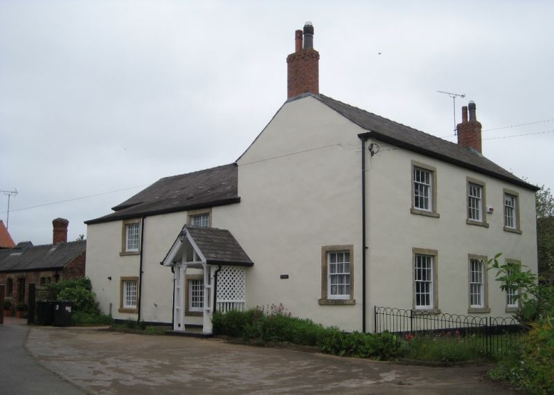
SUNDERLAND STREET
1. (north side)
5096 -----------------
No 2 (The Vicarage)
SK 5993 2/37
II
2.
Early C19. Roughcast. Slate roof. Two storeys. Three bays: sashes with
glazing bars. Door to side, with fielded panels and fanlight, Lower rear
wing.
Listing NGR: SK5934693302
External links are from the relevant listing authority and, where applicable, Wikidata. Wikidata IDs may be related buildings as well as this specific building. If you want to add or update a link, you will need to do so by editing the Wikidata entry.


Other nearby listed buildings
