Approximate Location Map
Large Map »
Latitude: 53.5066 / 53°30'23"N
Longitude: -1.1923 / 1°11'32"W
OS Eastings: 453669
OS Northings: 401402
OS Grid: SE536014
Mapcode National: GBR NW3W.PQ
Mapcode Global: WHDD7.N4G3
Plus Code: 9C5WGR45+J3
Entry Name: Boat Inn
Listing Date: 6 July 1981
Last Amended: 11 April 1986
Grade: II
Source: Historic England
Source ID: 1286435
English Heritage Legacy ID: 334571
ID on this website: 101286435
Location: Sprotbrough, Doncaster, South Yorkshire, DN5
County: Doncaster
Civil Parish: Sprotbrough and Cusworth
Traditional County: Yorkshire
Lieutenancy Area (Ceremonial County): South Yorkshire
Church of England Parish: Sprotbrough St Mary the Virgin
Church of England Diocese: Sheffield
Tagged with: Inn
SE50SW
7/150
6.7.81
SPROTBROUGH
SPROTBROUGH BOAT
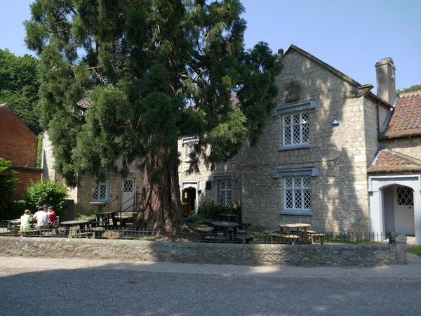
Boat Inn (formerly listed as Boat Farmhouse)
II
Farmhouse under conversion to public house. C17, altered mid C19, 1985
renovation. Rubble and ashlar limestone, stone slate eaves courses to pantile
roof. Irregular L-shaped plan. Mostly 2 storeys. Five 1st-floor windows with
wing projecting on left, one-bay addition to right and rear outshut. Large
quoins. Recessed central part has Tudor-arched door surround with square-sectioned
hoodmould; transomed 2-light window on right has latticed casements with
projecting sills and hoodmould. Two, 2-light windows above in same style. Gabled
bay to right breaks forward and has transomed 3-light window to each floor.
Copley arms on gable plaque. Lower addition to right, set back, has porch in
angle having Tudor-arched doorway with hoodmould, transomed 3-light window on right.
Wing to front left has projecting gable stack with offsets; ashlar-faced right
return with square-headed doorway flanked by transomed 2-light windows, two 2-light
windows to 1st floor. Shaped kneelers and roll-moulded gable copings. Brick shaft
to stack on front-left gable, ridge stack to main range, end stacks to main range
and addition on right.
Listing NGR: SE5366901402
External links are from the relevant listing authority and, where applicable, Wikidata. Wikidata IDs may be related buildings as well as this specific building. If you want to add or update a link, you will need to do so by editing the Wikidata entry.


Other nearby listed buildings
