Approximate Location Map
Large Map »
Latitude: 53.5506 / 53°33'2"N
Longitude: -1.0631 / 1°3'47"W
OS Eastings: 462173
OS Northings: 406406
OS Grid: SE621064
Mapcode National: GBR PW0C.NX
Mapcode Global: WHFF7.M0ZV
Plus Code: 9C5WHW2P+6Q
Entry Name: Manor House
Listing Date: 27 May 1953
Last Amended: 11 January 1988
Grade: II
Source: Historic England
Source ID: 1151557
English Heritage Legacy ID: 334762
ID on this website: 101151557
Location: Edenthorpe, Doncaster, South Yorkshire, DN3
County: Doncaster
Civil Parish: Edenthorpe
Built-Up Area: Doncaster
Traditional County: Yorkshire
Lieutenancy Area (Ceremonial County): South Yorkshire
Church of England Parish: Kirk Sandall and Edenthorpe Church of the Good Shepherd
Church of England Diocese: Sheffield
Tagged with: House
SOUTH YORKSHIRE
DONCASTER
5096
SE60NW EDENTHORPE CEDRIC ROAD
(south side)
1/61 Manor House (formerly
27th May 1953 listed as Edenthorpe
Manor Farmhouse and as
being in the Parish of
Barnby Dun with Kirk
Sandall)
- II
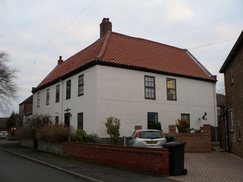
Farmhouse. Late C17. Red brick with ashlar quoins, all now painted;
renewed pantile roof. L-shaped plan: 2 storeys and attic, 5-bay front with
wing to rear right having outshut in the angle. Chamfered stone plinth. C20
part-glazed door and overlight to bay 4 in cemented surround with raised
keystone; above door are fixed letters of later date reading
'MANOR/1606/HOUSE'. Other bays on each floor have C20 casements with glazing
bars, those to ground floor beneath flat arches. Plain brick kneelers and
copings to left gable, hipped end to roof on right. Small brick end stack on
left; older ridge stack on right. Right return: cogged eaves.
Interior: enlarged ground-floor room on left has a deeply-moulded ceiling
beam and a bressumer beam incorporated into C20 fireplace; original roof
structure with principal-rafter trusses having curved collars and butt
purlins, no ridge piece.
Listing NGR: SE6217306406
External links are from the relevant listing authority and, where applicable, Wikidata. Wikidata IDs may be related buildings as well as this specific building. If you want to add or update a link, you will need to do so by editing the Wikidata entry.


Other nearby listed buildings
