Approximate Location Map
Large Map »
Latitude: 53.4681 / 53°28'5"N
Longitude: -1.2723 / 1°16'20"W
OS Eastings: 448403
OS Northings: 397066
OS Grid: SK484970
Mapcode National: GBR MXKB.BH
Mapcode Global: WHDDD.F3C3
Plus Code: 9C5WFP9H+63
Entry Name: Church of St John the Baptist
Listing Date: 29 March 1968
Grade: II*
Source: Historic England
Source ID: 1286668
English Heritage Legacy ID: 335521
ID on this website: 101286668
Location: St John the Baptist's Church, Hooton Roberts, Rotherham, South Yorkshire, S65
County: Rotherham
Civil Parish: Hooton Roberts
Traditional County: Yorkshire
Lieutenancy Area (Ceremonial County): South Yorkshire
Church of England Parish: Hooton Roberts St John
Church of England Diocese: Sheffield
Tagged with: Church building
The entry for the following shall be upgraded from Grade II to Grade II* (star):
SK 49 NE HOOTON ROBERTS DONCASTER ROAD
(North-West Side)
6/11 Church of
29.3.68 St. John the Baptist
GV
------------------------------------
SK49NE HOOTON ROBERTS DONCASTER ROAD
(north-west side)
6/11 Church of
29.3.68 St. John the Baptist
GV II
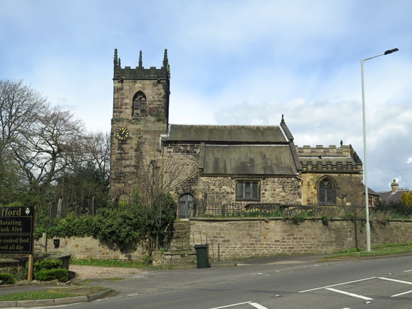
Church. C12 core, rebuilt C15, extensive C19 restoration. Sandstone:
early work irregular rubble, C15 work ashlar. Slate roofs. West
tower, small nave with partial aisle to south and lean-to porch in
angle with nave, chancel with south chapel. Tower: Perpendicular.
Chamfered plinth and moulded band to tall lower stage. 3-light west
window beneath depressed, 4-centred arch. Pointed arch to door of
south-east vice. Iron-faced clock. 2-light belfry openings. Renewed
embattled parapet with crocketted pinnacles. Weathervane. Nave:
irregular rubble heightened in ashlar. Diagonal offset buttresses
to west end. Square-headed windows with hoodmoulds to aisle and north
side. Aisle: chamfered plinth; 3-light window; chamfered eaves band;
kneelers and gable coping. Deeply-coursed stonework to porch, round-
arched south doorway. North wall: two 3-light windows with blocked
doorway to west; lancet and large offset buttress to east. Rebuilt
gable with kneelers, copings and cross. Chancel: lower, embattled
with limestone merlons. East window: restored, 3-lights beneath
round arch. Lancet to north wall. South chapel: restored, pointed
2-light window. Embattled.
Interior: pointed south doorway with old oak door. Double-chamfered,
pointed-arch to aisle. Chancel arch: restored round arch on semicircular
responds with crocketted capitals. Arch to south chapel similar with
quarter-mould and chamfer, unrestored. Good 1701 wall monument on
north wall beneath tower. Stained glass: figure of an Archbishop in
lancet at east end of nave north wall, C13 or early C14, restored.
The First Earl of Strafford (executed 1641), his widow and daughter
thought to have been buried beneath the chancel.
Listing NGR: SK4840397066
External links are from the relevant listing authority and, where applicable, Wikidata. Wikidata IDs may be related buildings as well as this specific building. If you want to add or update a link, you will need to do so by editing the Wikidata entry.


Other nearby listed buildings
