Approximate Location Map
Large Map »
Latitude: 53.4677 / 53°28'3"N
Longitude: -1.272 / 1°16'19"W
OS Eastings: 448425
OS Northings: 397015
OS Grid: SK484970
Mapcode National: GBR MXKB.DN
Mapcode Global: WHDDD.F3JG
Plus Code: 9C5WFP9H+36
Entry Name: Barn Approximately 35 Metres to the South East of Church of St John
Listing Date: 29 March 1968
Last Amended: 21 August 1985
Grade: II
Source: Historic England
Source ID: 1132773
English Heritage Legacy ID: 335524
ID on this website: 101132773
Location: Hooton Roberts, Rotherham, South Yorkshire, S65
County: Rotherham
Civil Parish: Hooton Roberts
Traditional County: Yorkshire
Lieutenancy Area (Ceremonial County): South Yorkshire
Church of England Parish: Hooton Roberts St John
Church of England Diocese: Sheffield
Tagged with: Barn
SK49NE HOOTON ROBERTS DONCASTER ROAD
(south-east side)
6/15 Barn approximately
35 metres to south-east
29.3.68 of Church of St. John
(formerly listed as
Manor House Barn ,
known as the Tythe Barn)
GV II
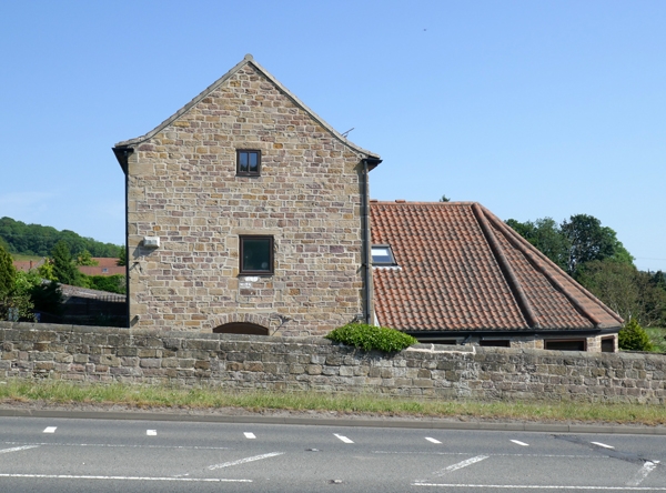
Barn now disused. Late C18, truncated and roadside gable rebuilt
following C20 road widening. Coursed, squared sandstone rubble;
sheet asbestos roof. 2 storeys, 6½ bays (internal); upper storey
has 2 rows of windows giving a 3-storey appearance.
Uphill side: quoins. Quoined, segmental-arched doorway to right
of centre with part-dismantled buttress to its left. 3 rows of
segmental-arched openings partly closed by wall stone mullions.
Downhill side: derelict apsidal horse engine house to left with
doorway into barn; adjacent side wall of barn collapsed and now
with timber shoring. Ground-floor windows largely blocked, most
upper-floor windows retain stone divisions; two square loading
windows with square-faced surrounds.
Interior: brick-arched window heads. C18 style king-post trusses
re-use tie beams from a timber-framed building.
Illustrated in: P. Fowler, Farms in England Prehistoric to Present,
1983, RCHM, plate 73.
Listing NGR: SK4842597015
External links are from the relevant listing authority and, where applicable, Wikidata. Wikidata IDs may be related buildings as well as this specific building. If you want to add or update a link, you will need to do so by editing the Wikidata entry.


Other nearby listed buildings
