Approximate Location Map
Large Map »
Latitude: 53.4992 / 53°29'57"N
Longitude: -1.3587 / 1°21'31"W
OS Eastings: 442634
OS Northings: 400474
OS Grid: SE426004
Mapcode National: GBR LWYZ.MB
Mapcode Global: WHDD5.397R
Plus Code: 9C5WFJXR+MG
Entry Name: Newhill Grange Farmhouse
Listing Date: 21 August 1985
Grade: II
Source: Historic England
Source ID: 1286490
English Heritage Legacy ID: 335561
ID on this website: 101286490
Location: West Melton, Rotherham, South Yorkshire, S63
County: Rotherham
Electoral Ward/Division: Wath
Parish: Non Civil Parish
Traditional County: Yorkshire
Lieutenancy Area (Ceremonial County): South Yorkshire
Church of England Parish: Wath Upon Dearne All Saints
Church of England Diocese: Sheffield
Tagged with: Farmhouse
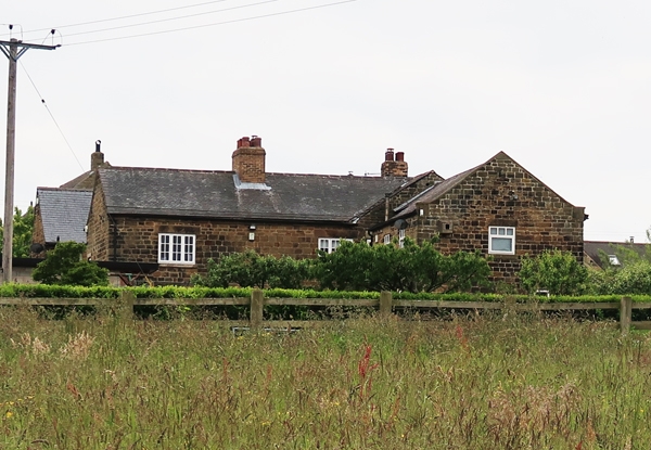
SE40SW WATH UPON DEARNE NEWHILL ROAD
(north end, off)
2/52 Newhill Grange
Farmhouse
II
Farmhouse. Mid C18, partly refenestrated C20. Coursed, squared
sandstone; Welsh slate roof, with lower courses of stone slates.
Main range with cross-wing to right and wing to rear left. 2 storeys;
cellar and attic to cross-wing. Main range: four 1st-floor windows.
Quoins. Near-central, part-glazed door in altered, partly-quoined
surround. Flanking windows: inserted 2- and 3-light iron casements
with projecting sills and plain lintels; continuous band interrupted
by inserted lintels. 1st-floor windows as ground floor. Blocked
single-light window over door has original square-faced surround.
Renewed brick ridge-stack above door. Wing to right: two 1st-floor
windows. Chamfered quoins. Sashes with glazing bars in tall, square-
faced surrounds; ground-floor lintel band. Single window to attic.
Shaped kneelers, gable copings. Renewed brick end stack to right.
Rear: main range has intact 3-light, square-faced, mullioned window
with similar 2-light window above. Right return: tall stair-window
to cross-wing. Attached farmbuildings not of special interest.
Listing NGR: SE4263400474
External links are from the relevant listing authority and, where applicable, Wikidata. Wikidata IDs may be related buildings as well as this specific building. If you want to add or update a link, you will need to do so by editing the Wikidata entry.


Other nearby listed buildings
