Approximate Location Map
Large Map »
Latitude: 51.4748 / 51°28'29"N
Longitude: -2.7235 / 2°43'24"W
OS Eastings: 349844
OS Northings: 175337
OS Grid: ST498753
Mapcode National: GBR JK.L7MC
Mapcode Global: VH88K.R618
Plus Code: 9C3VF7FG+WH
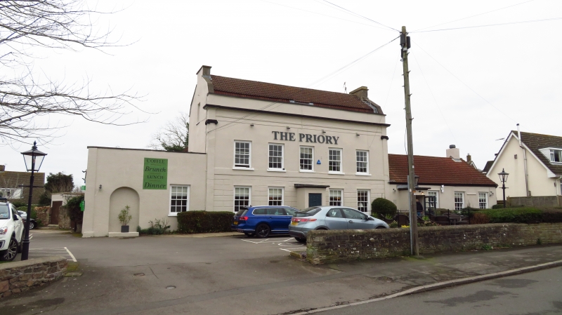
Entry Name: The Priory
Listing Date: 13 October 1952
Grade: II
Source: Historic England
Source ID: 1321001
English Heritage Legacy ID: 33565
ID on this website: 101321001
Location: Portbury, North Somerset, BS20
County: North Somerset
Civil Parish: Portbury
Traditional County: Somerset
Lieutenancy Area (Ceremonial County): Somerset
Tagged with: Pub
ST 47 NE PORTBURY STATION ROAD (east side)
1/170 The Priory
13.10.52
- II
House, now a public house. Late C18. Rendered, the ground floor is rusticated;
C20 tiled, mansard roof with coped raised verges; coped parapet and moulded
cornice. 2 storeys and attics in C20 dormers. 5 bays and end Ionic pilasters:
glazing bar sash windows; plain band over ground floor. Central C20 projecting
porch. Single bay, single storey wings to each side; parapet; round headed
door to left and C20 porch to right.
Listing NGR: ST4984475340
External links are from the relevant listing authority and, where applicable, Wikidata. Wikidata IDs may be related buildings as well as this specific building. If you want to add or update a link, you will need to do so by editing the Wikidata entry.


Other nearby listed buildings
