Approximate Location Map
Large Map »
Latitude: 53.3671 / 53°22'1"N
Longitude: -1.2113 / 1°12'40"W
OS Eastings: 452578
OS Northings: 385874
OS Grid: SK525858
Mapcode National: GBR MYZH.KP
Mapcode Global: WHDDT.CMFK
Plus Code: 9C5W9Q8Q+VF
Entry Name: Hall Farmhouse and Attached Farmbuildings Under Same Roof
Listing Date: 29 July 1966
Last Amended: 15 October 1986
Grade: II
Source: Historic England
Source ID: 1132693
English Heritage Legacy ID: 335749
ID on this website: 101132693
Location: Dinnington, Rotherham, South Yorkshire, S25
County: Rotherham
Civil Parish: Dinnington St. John's
Built-Up Area: Dinnington
Traditional County: Yorkshire
Lieutenancy Area (Ceremonial County): South Yorkshire
Church of England Parish: Dinnington St Leonard
Church of England Diocese: Sheffield
Tagged with: Farmhouse
SK58NW
2/3
29.7.66
DINNINGTON ST. JOHN'S
LAUGHTON ROAD
(east side)
Hall Farmhouse and attached farmbuildings under same roof
(formerly listed as Dinnington Hall Farmhouse)
II
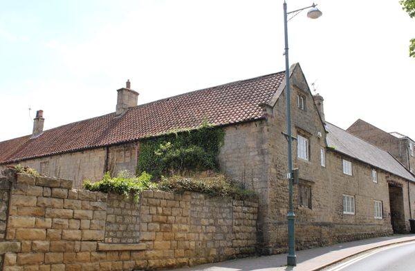
Farmhouse and attached farmbuildings. Early C17 of 2 builds, altered.
Deeply-coursed, squared limestone, Welsh slate and pantile roofs. L-shaped plan
with earlier gabled bay on left extending as elongated wing to rear. 2 storeys
with attics, 6-bay roadside front. Gabled bay 1 has large quoins and chamfered
plinth; 3-light double-chamfered mullioned window with dripstone to ground floor;
similar 1st-floor window now with lowered sill, no mullions and 3-light casement
with glazing bars, inserted casement on right; intact 2-light attic window with
dripstone. Bays on right have wallstone plinth and quoined central wagon entrance
with wooden lintel. Bays 2 and 3 have 2- and 3-light casements with glazing bars
all but lower right window with unaltered double-chamfered surrounds. Bays 5 and 6
have an inserted 1st-floor casement to left of blocked 2-light double-chamfered
window without mullion. Shaped kneelers and gable copings to bay 1 and right end
of range, renewed ashlar ridge stack between bays 2 and 3. Rear: some traces of
original windows, blocked doorway to right of wagon entrance; wing mostly
farmbuildings with three C20 tractor openings. Left return: blocked mullioned
windows with dripstones, a ground-floor window now without mullions has C20
casement; pantile roof with corniced ashlar ridge stack at end of house-part of
wing.
Interior: exposed in rear wing are collared principal-rafter trusses with some
windbraces to double purlins.
Listing NGR: SK5257885874
External links are from the relevant listing authority and, where applicable, Wikidata. Wikidata IDs may be related buildings as well as this specific building. If you want to add or update a link, you will need to do so by editing the Wikidata entry.


Other nearby listed buildings
