Approximate Location Map
Large Map »
Latitude: 53.3255 / 53°19'31"N
Longitude: -1.1765 / 1°10'35"W
OS Eastings: 454946
OS Northings: 381271
OS Grid: SK549812
Mapcode National: GBR NY7Z.2M
Mapcode Global: WHDF0.WNYY
Plus Code: 9C5W8RGF+69
Entry Name: Chesterfield Canal Bridge 37 and Turnerwood Lock with Associated Overflow Structure at Cinder Hill
Listing Date: 15 October 1986
Grade: II
Source: Historic England
Source ID: 1314642
English Heritage Legacy ID: 335811
ID on this website: 101314642
Location: Shireoaks, Rotherham, South Yorkshire, S81
County: Rotherham
Civil Parish: North and South Anston
Traditional County: Yorkshire
Lieutenancy Area (Ceremonial County): South Yorkshire
Church of England Parish: Worksop Christ Church and Shireoaks
Church of England Diocese: Southwell and Nottingham
NORTH AND SOUTH ANSTON CHESTERFIELD CANAL
SK58SW
5/62 Bridge 37 and Turnerwood
Lock with associated
overflow structure at
Cinder Hill
II
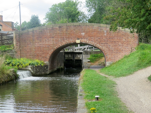
Bridge with associated lock and overflow structure. Late C18, bridge probably
early C19. For the Chesterfield Canal Company. Single-span bridge with integral
lock to west and overflow channel emerging at sluice near south-east corner
of bridge. Bridge: round-nosed brick voussoirs to basket arch, abutment walls
curve out to terminate at rounded projecting end piers, parapet with stone copings
curves down to each side. Brick-arched overflow tunnel emerges near south-
east corner and empties via lined sluice into canal. Lock: stone entry and
exit walls; stone course near low water level with brickwork above; ashlar lock-
gate recesses with hollow-quoined heel-post housings. Important element of
the Chesterfield Canal surveyed by James Brindley and built between 1771 and
1777 and remaining in water through the parishes of Thorpe Salvin and North
and South Anston. Forms eastern end of the Turnerwood Flight of locks (q.v.).
Listing NGR: SK5494681270
External links are from the relevant listing authority and, where applicable, Wikidata. Wikidata IDs may be related buildings as well as this specific building. If you want to add or update a link, you will need to do so by editing the Wikidata entry.


Other nearby listed buildings
