Approximate Location Map
Large Map »
Latitude: 53.3287 / 53°19'43"N
Longitude: -1.2002 / 1°12'0"W
OS Eastings: 453364
OS Northings: 381610
OS Grid: SK533816
Mapcode National: GBR NY1Y.YG
Mapcode Global: WHDF0.JLPH
Plus Code: 9C5W8QHX+FW
Entry Name: Chesterfield Canal Bridge 35 and Top Treble Lock (To West of Low Spring Wood)
Listing Date: 15 October 1986
Grade: II
Source: Historic England
Source ID: 1132686
English Heritage Legacy ID: 335832
ID on this website: 101132686
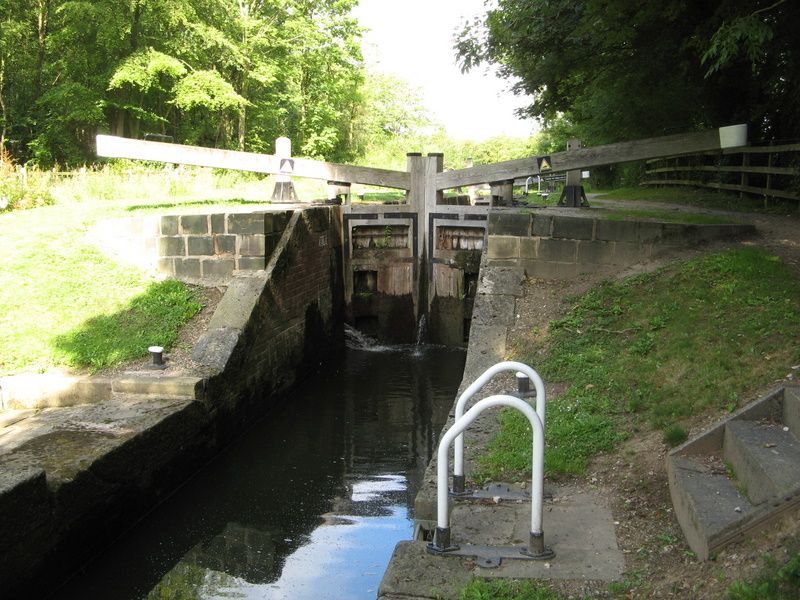
THORPE SALVIN CHESTERFIELD CANAL
SK58SW
SK53378161
5/84 Bridge 35 and Top
Treble lock (to west
of Low Spring Wood)
GV II
Bridge and attached triple lock. Late-C18 locks probably altered, bridge dated
1835. For the Chesterfield Canal Company. Red brick with ashlar voussoirs
to arch of bridge and ashlar lock-gate housings. Single-span bridge at east
end of 3-lock staircase. Bridge: chamfered ashlar jambs and projecting springing
stones to chamfered segmental arch, projecting keystone with dated ledge over.
Southern wing walls curve out and terminate at projecting end piers. Northern
approach ramp is of rubble stone on east side. Some brick renewal to parapet
and some stone copings replaced in concrete. Locks: rubble stone entry and
exit walls, the locks themselves lined with brick and now missing original stone
edgings. Ashlar lock-gate recesses with hollow-quoined heel-post housings and
with arched tunnels on south side leading to overflow channel. Important element
of the Chesterfield Canal surveyed by James Brindley and built between 1771
and 1777 but obviously improved and renewed in the C19. Forms western end of
the Thorpe Flight of locks (q.v.).
Listing NGR: SK5336481610
External links are from the relevant listing authority and, where applicable, Wikidata. Wikidata IDs may be related buildings as well as this specific building. If you want to add or update a link, you will need to do so by editing the Wikidata entry.


Other nearby listed buildings
