Approximate Location Map
Large Map »
Latitude: 53.3629 / 53°21'46"N
Longitude: -1.2983 / 1°17'53"W
OS Eastings: 446796
OS Northings: 385347
OS Grid: SK467853
Mapcode National: GBR MYCK.Q6
Mapcode Global: WHDDS.1Q2S
Plus Code: 9C5W9P72+5M
Entry Name: The Grange
Listing Date: 29 March 1968
Grade: II
Source: Historic England
Source ID: 1314658
English Heritage Legacy ID: 335892
ID on this website: 101314658
Location: Aston, Rotherham, South Yorkshire, S26
County: Rotherham
Civil Parish: Aston cum Aughton
Built-Up Area: Swallownest
Traditional County: Yorkshire
Lieutenancy Area (Ceremonial County): South Yorkshire
Church of England Parish: Aston cum Aughton All Saints
Church of England Diocese: Sheffield
Tagged with: Building
This list entry was subject to a Minor Amendment on 23 December 2021 to update text and reformat to current standards
SK48NE
6/17
ASTON-CUM-AUGHTON
Aston
WORKSOP ROAD (north side)
The Grange
29.3.68
GV
II
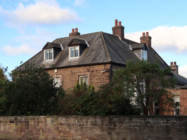
House. Early C18 with C19 addition. Coursed, dressed sandstone, graduated Westmorland slate roof; C19 addition in brick with Welsh slate roof, two-storey-with-attic, three-bay main range having lower additions to rear and C19 four-bay wing projecting from right return. Main range large raised quoins. Central doorway (now window) in architrave with pulvinated frieze and cornice. Flanking, transomed casements with glazing bars in raised ashlar surrounds with raised keystones; similar first-floor windows. Two-span roof hipped at front with two gabled dormers and stacks to each side ridge. Low wing projecting on right has margin-light-glazed sash adjacent to main range and four-pane sashes linked by sill band; brick ridge stack and end stack off right. Right return of main range: wooden two-storey, bay-window addition with French window; roof dormer and coped rear gable with stack. Left return: glazed one-storey porch; four-pane sashes in flush square-faced surrounds, coped rear gable with stack. Lower wing on left has former three-light, square-faced mullioned window to ground floor now without mullions, intact three-light, mullioned window above.
Listing NGR: SK4678485358
External links are from the relevant listing authority and, where applicable, Wikidata. Wikidata IDs may be related buildings as well as this specific building. If you want to add or update a link, you will need to do so by editing the Wikidata entry.


Other nearby listed buildings
