Approximate Location Map
Large Map »
Latitude: 53.4559 / 53°27'21"N
Longitude: -1.2735 / 1°16'24"W
OS Eastings: 448338
OS Northings: 395709
OS Grid: SK483957
Mapcode National: GBR MXKG.2W
Mapcode Global: WHDDD.DDTG
Plus Code: 9C5WFP4G+9H
Entry Name: Stable Block Approximately 40 Metres to North East of Ravenfield Hall Farmhouse
Listing Date: 29 March 1968
Last Amended: 1 April 1987
Grade: II
Source: Historic England
Source ID: 1193108
English Heritage Legacy ID: 335958
ID on this website: 101193108
Location: Ravenfield, Rotherham, South Yorkshire, S65
County: Rotherham
Civil Parish: Ravenfield
Traditional County: Yorkshire
Lieutenancy Area (Ceremonial County): South Yorkshire
Church of England Parish: Ravenfield St James
Church of England Diocese: Sheffield
Tagged with: Stable
RAVENFIELD RAVENFIELD LANE
SK49NE
(east side, off)
1/83 Stable-block
29.3.68 approximately 40 metres
to north-east of
Ravenfield Hall Farmhouse
(formerly listed as
Ravenfield Hall Stables)
GV II
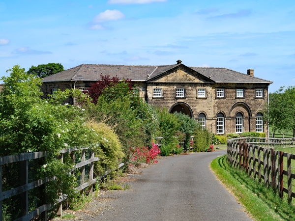
Stable-block. Mid-late C18. By John Carr for the Ravenfield Hall estate.
Horizontally-tooled sandstone, Welsh slate roof. 2 storeys, 3:3:3 bays.
Plinth, large quoins, continuous impost band to ground floor. Central bays
break forward and have round-arched carriage entrance with archivolt flanked
by later casements in original round-headed ashlar surrounds with archivolts.
Windows to outer bays similar, those to bays 2 and 8 set in recessed panels
beneath archivolts matching that of carriage entrance; bay 3 window now a
door, external brick stack built between bays 1 and 2 (not of special
interest). 1st floor: unequally-hung 12-pane sashes in square-faced
surrounds with projecting sills. Modillioned eaves cornice rising as central
3-bay pediment with banded ball finials to its left and apex. Hipped roof.
Rear: external steps to loft doors on left and right; 1st-floor band beneath
7 oculi; plain cornice. Interior not inspected. Architraved door to each
side within archway.
Listing NGR: SK4833895709
External links are from the relevant listing authority and, where applicable, Wikidata. Wikidata IDs may be related buildings as well as this specific building. If you want to add or update a link, you will need to do so by editing the Wikidata entry.


Other nearby listed buildings
