Approximate Location Map
Large Map »
Latitude: 53.3888 / 53°23'19"N
Longitude: -1.2712 / 1°16'16"W
OS Eastings: 448569
OS Northings: 388238
OS Grid: SK485882
Mapcode National: GBR MYK7.LY
Mapcode Global: WHDDS.F2XY
Plus Code: 9C5W9PQH+GG
Entry Name: Farm View Cottages
Listing Date: 1 April 1987
Grade: II
Source: Historic England
Source ID: 1314691
English Heritage Legacy ID: 335968
ID on this website: 101314691
Location: Brampton en le Morthen, Rotherham, South Yorkshire, S66
County: Rotherham
Civil Parish: Thurcroft
Traditional County: Yorkshire
Lieutenancy Area (Ceremonial County): South Yorkshire
Church of England Parish: Thurcroft St Simon and St Jude
Church of England Diocese: Sheffield
Tagged with: Cottage
This list entry was subject to a Minor Amendment on 17 January 2022 to update text and reformat to current standards
SK48NE
6/93
THURCROFT
Brampton-en-le-Morthen
BRAMPTON ROAD (west side)
Farm View Cottages
(Formerly listed as Farmview Cottage and as on Village Street)
GV
II
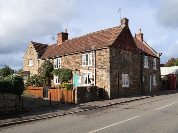
House now three cottages. C17, altered. Coursed rubble sandstone, pantile roof. L-shaped plan having unequal length rear wings infilled by outshut to main range. Two storeys, 1:3 windows to first floor. Large quoins. Gabled bay to left has C20 porch (not of special interest) to left of two-light casement; old first-floor casement with glazing bars in double-chamfered surround; blocked double-chamfered attic window; shaped kneelers, copings removed.
Cottage on right has later doorway flanked by C20 casements, all with plain lintels; remains of C17 window surrounds built into wall. First floor: two three-light wooden casements with horizontal glazing bars, wooden lintels. Straight joint to left of this cottage beyond which are traces of blocked doorway with small first-floor casement over. Brick ridge stack on left, brick end stack on right. Rear: wing gable on left has two, blocked, double-chamfered, single-light windows; shaped kneelers with carved scrolls; chamfered gable copings and brick end stack. Gable on right has a two-light double-chamfered window surround to first floor and similar blocked opening to attic. Left return: intact three-light double-chamfered, mullioned window to first-floor. Right return (facing roadside): gable end of main range has a blocked C17 three-light mullion window to first floor; later brickwork to gable. Rear-right wing derelict at time of resurvey.
Listing NGR: SK4856988238
External links are from the relevant listing authority and, where applicable, Wikidata. Wikidata IDs may be related buildings as well as this specific building. If you want to add or update a link, you will need to do so by editing the Wikidata entry.


Other nearby listed buildings
