Approximate Location Map
Large Map »
Latitude: 53.8377 / 53°50'15"N
Longitude: -1.7061 / 1°42'22"W
OS Eastings: 419435
OS Northings: 437978
OS Grid: SE194379
Mapcode National: GBR JW1.3V
Mapcode Global: WHC93.RSRT
Plus Code: 9C5WR7QV+3G
Entry Name: The Bridge
Listing Date: 4 September 1952
Grade: II
Source: Historic England
Source ID: 1183826
English Heritage Legacy ID: 336056
ID on this website: 101183826
Location: Apperley Bridge, Bradford, West Yorkshire, BD10
County: Bradford
Electoral Ward/Division: Idle and Thackley
Parish: Non Civil Parish
Built-Up Area: Bradford
Traditional County: Yorkshire
Lieutenancy Area (Ceremonial County): West Yorkshire
Church of England Parish: Greengates St John the Evangelist
Church of England Diocese: Leeds
Tagged with: Bridge
1.
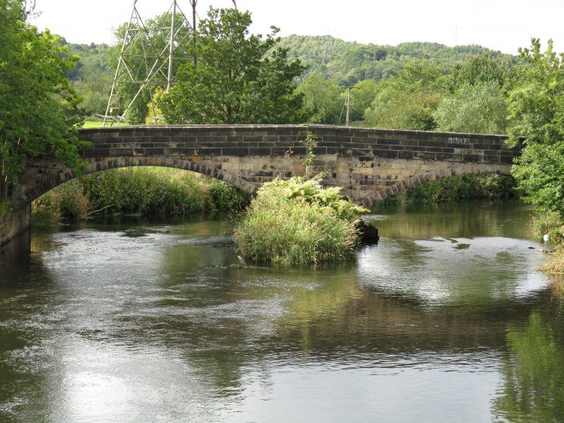
5111 APPERLEY LANE
Apperley Bridge BD10
The Bridge
SE 1937 18/14 4.9.52
II
2.
Latter part of C16 or early C17. Ashlar bridge with 2 slightly pointed arches,
outwaters and plain parapet. Central inscription partially obliterated.
Listing NGR: SE1943537978
External links are from the relevant listing authority and, where applicable, Wikidata. Wikidata IDs may be related buildings as well as this specific building. If you want to add or update a link, you will need to do so by editing the Wikidata entry.


Other nearby listed buildings
