Approximate Location Map
Large Map »
Latitude: 53.8201 / 53°49'12"N
Longitude: -1.9465 / 1°56'47"W
OS Eastings: 403621
OS Northings: 435985
OS Grid: SE036359
Mapcode National: GBR GSV8.DB
Mapcode Global: WHB82.27DR
Plus Code: 9C5WR3C3+3C
Entry Name: North Ives Bridge
Listing Date: 23 February 1955
Grade: II
Source: Historic England
Source ID: 1134069
English Heritage Legacy ID: 338294
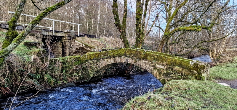
Also known as: Donkey Bridge
ID on this website: 101134069
Location: Marsh Top, Bradford, West Yorkshire, BD22
County: Bradford
Civil Parish: Oxenhope
Traditional County: Yorkshire
Lieutenancy Area (Ceremonial County): West Yorkshire
Church of England Parish: Oxenhope St Mary the Virgin
Church of England Diocese: Leeds
Tagged with: Bridge Packhorse bridge
KEIGHLEY MARSH LANE
SE 0235 and SE 0335 (off east side)
23/194 Marsh
23.2.55 North Ives Bridge
- II
Packhorse Bridge. Date uncertain. Stone. Single, steeply-arched span supports
narrow bridge with parapets. 3 steps added at each end to reduce gradient.
Listing NGR: SE0362135985
External links are from the relevant listing authority and, where applicable, Wikidata. Wikidata IDs may be related buildings as well as this specific building. If you want to add or update a link, you will need to do so by editing the Wikidata entry.


Other nearby listed buildings
