Approximate Location Map
Large Map »
Latitude: 50.3509 / 50°21'3"N
Longitude: -3.5788 / 3°34'43"W
OS Eastings: 287774
OS Northings: 51303
OS Grid: SX877513
Mapcode National: GBR QS.RB6J
Mapcode Global: FRA 38D3.MKV
Plus Code: 9C2R9C2C+9F
Entry Name: Seven Stars Public House
Listing Date: 23 October 1972
Grade: II
Source: Historic England
Source ID: 1293160
English Heritage Legacy ID: 387195
ID on this website: 101293160
Location: Dartmouth, South Hams, Devon, TQ6
County: Devon
District: South Hams
Civil Parish: Dartmouth
Built-Up Area: Dartmouth
Traditional County: Devon
Lieutenancy Area (Ceremonial County): Devon
Church of England Parish: Dartmouth Townstal
Church of England Diocese: Exeter
Tagged with: Pub
SX874510
673-1/8/6823/10/72
DARTMOUTH
CHURCH CLOSE (South side)
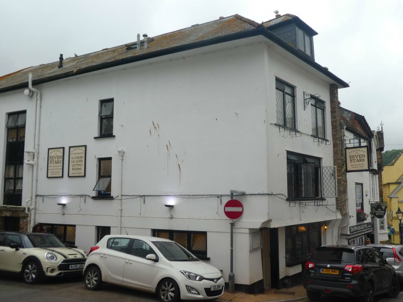
Seven Stars Public House
GII
Includes: No.8 Seven Stars Public House SMITH STREET.
Public house, made by joining together two small houses, one onto Church Close and another onto Smith Street. Late C16/early C17 house onto Smith Street, probably C17 house onto Church Close, both with substantial later alterations. Mixed construction; stone rubble side walls, the western one apparently much rebuilt, and rest is plastered timber-framing, lightly blocked as ashlar; stacks with rendered chimneyshafts; slate roof.
PLAN: originally two houses, back to back: both were small houses end onto the street with stacks in their eastern party wall.
EXTERIOR: three storeys with attics; narrow one-window Church Close frontage is essentially late C18/early C19 with C20 alterations. Ground-floor windows are C20 casements with leaded diamond-pane effect (similar to the windows on the other two sides), that to left probably blocking the original doorway off Church Close. Canted bay above through first and second floors containing front pairs of twelve-pane sashes with narrow side four-pane sashes. Third-floor casement with truncated pyramid head under half-hipped end to the roof. Western side wall (to left) an irregular three-window range, all C20 windows, with C20 doorway left of centre (including a couple of architectural fragments from the church over the lintel). Narrow south front onto Smith Street: here end of right (eastern) side wall is exposed and corbels out to carry the deep first-floor jetty which indicates the survival of some of the late C16/early C17 fabric behind the plaster. Oak doorway to right is a late C16/early C17 low Tudor arch with chamfered surround and sunk spandrels. All C20 windows this side. Hipped roof on deep eaves with plastered soffit which is carried round the left end.
INTERIOR: Largely the result of C19 and C20 modernisations. There is a great deal of exposed timber on the ceilings, some of which has been introduced.
Listing NGR: SX8777251310
External links are from the relevant listing authority and, where applicable, Wikidata. Wikidata IDs may be related buildings as well as this specific building. If you want to add or update a link, you will need to do so by editing the Wikidata entry.


Other nearby listed buildings
