Approximate Location Map
Large Map »
Latitude: 51.2882 / 51°17'17"N
Longitude: 0.4021 / 0°24'7"E
OS Eastings: 567595
OS Northings: 157082
OS Grid: TQ675570
Mapcode National: GBR NPK.0H7
Mapcode Global: VHJM4.XWFB
Plus Code: 9F327CQ2+7R
Entry Name: St Leonard's Tower
Listing Date: 30 November 1993
Grade: I
Source: Historic England
Source ID: 1219087
English Heritage Legacy ID: 392446
Also known as: St Leonard's Tower, West Malling
ID on this website: 101219087
Location: St Leonard's Street, Tonbridge and Malling, Kent, ME19
County: Kent
District: Tonbridge and Malling
Civil Parish: West Malling
Traditional County: Kent
Lieutenancy Area (Ceremonial County): Kent
Church of England Parish: West Malling St Mary
Church of England Diocese: Rochester
Tagged with: Architectural structure Tower Keep
TQ6757
1156-0/2/128
WEST MALLING
ST LEONARDS STREET
St Leonard's Tower
GV
I
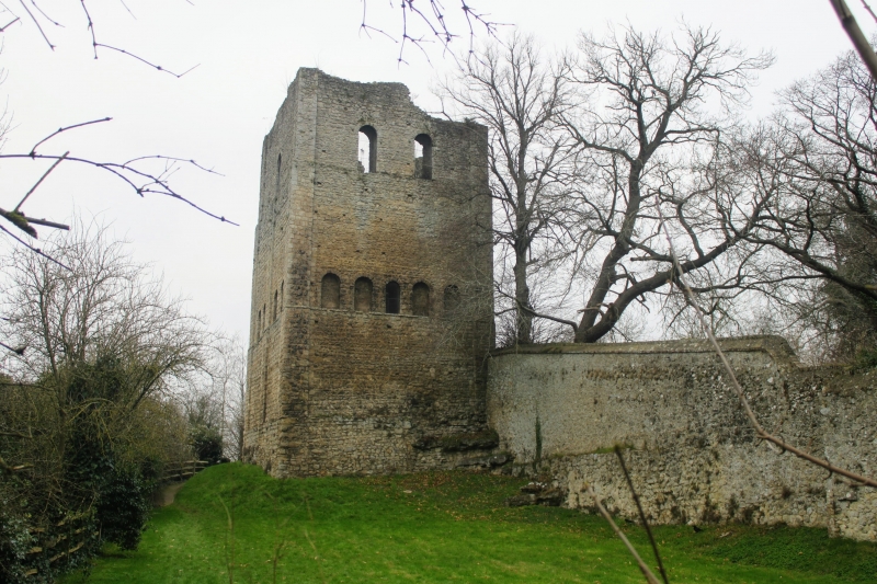
Former castle, Built by Gundulf Bishop of Rochester 1077-1108
as his fortified residence or castle. It is one of the best
examples extant of an Early Norman Keep. Built of stone with
tufa dressings, 32ft square at the base, 60ft high on its
north and east faces and 70 ft on the 2 other faces, the
difference due to the inclined surface of the rocky shelf on
which it is built. Corner buttresses. 3 stages. The 1st stage
has traces of herringbone-work. Central buttress to left side
elevation. 2nd stage has 5 round-headed arches on the east
side, only the central one open, the rest blank. 2nd stage has
2 round-headed arches to east side and one to south side. West
side has round-headed entrance to ground floor, round-headed
arch to first and second floors and loop lights to buttresses.
North side has 1 round-headed window.
Internal evidence to suggest there were upper and lower
floors, the lower only about 5ft above ground level.
(Buildings of England: Newman J: West Kent and the Weald:
580).
Listing NGR: TQ6759557082
External links are from the relevant listing authority and, where applicable, Wikidata. Wikidata IDs may be related buildings as well as this specific building. If you want to add or update a link, you will need to do so by editing the Wikidata entry.


Other nearby listed buildings
