Approximate Location Map
Large Map »
Latitude: 52.5554 / 52°33'19"N
Longitude: -0.1321 / 0°7'55"W
OS Eastings: 526732
OS Northings: 296923
OS Grid: TL267969
Mapcode National: GBR J01.WYP
Mapcode Global: VHGKY.N1JC
Plus Code: 9C4XHV49+55
Entry Name: Wilderness House
Listing Date: 11 August 1950
Grade: II*
Source: Historic England
Source ID: 1287350
English Heritage Legacy ID: 402596
ID on this website: 101287350
Location: Briggate, Fenland, Cambridgeshire, PE7
County: Cambridgeshire
District: Fenland
Civil Parish: Whittlesey
Built-Up Area: Whittlesey
Traditional County: Cambridgeshire
Lieutenancy Area (Ceremonial County): Cambridgeshire
Church of England Parish: Whittlesey St Andrew
Church of England Diocese: Ely
Tagged with: House
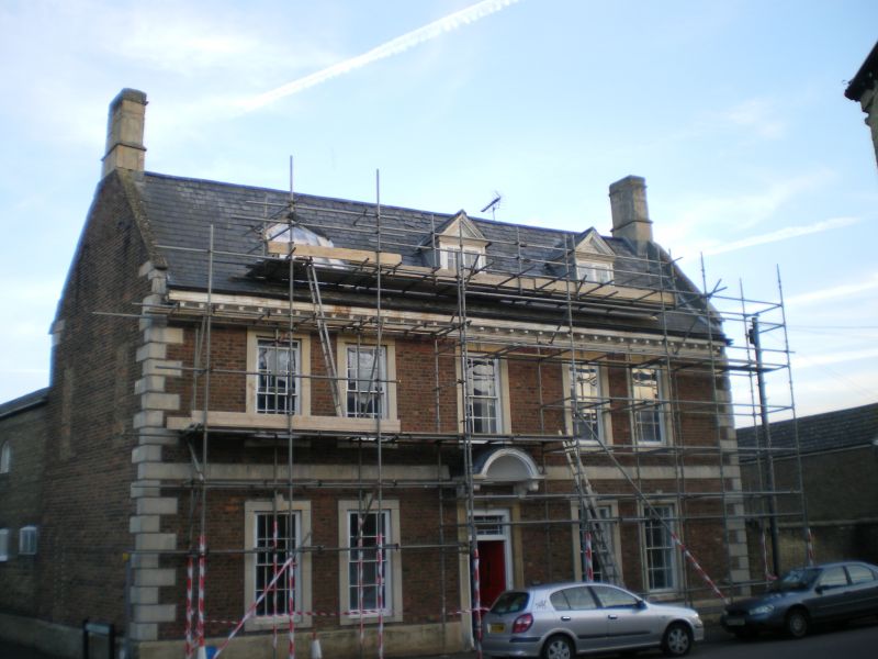
TL 2696 WHITTLESEY LONDON STREET
(South Side)
21/100 No. 47
11.8.50 (Wilderness House)
II*
House. Early C18, early C19 and 1883. Local brick, mostly Flemish bond,
with limestone dressings. Steeply pitched roof covered with slates and
having end parapets with stone coping and a wood modillion eaves cornice.
Original, symmetrical, flush end stacks of stone with string cornices and
entablature. Plan of main range with early C19 service wing at rear forming
an L-plan. Two storeys and attics. Three original gable dormers.
Symmetrical elevation of two storeys framed by rusticated quoins of stone and
divided by plain band. Raised stone surrounds and key blocks to five C19
hung sashes. Four similar windows at ground floor and central doorway with
similar doorcase and original semi-circular plain coved hood on scroll
brackets. Door of six raised and fielded panels with rectangular fanlight.
Left hand gable end has three narrow, blocked window openings. House
extended at rear and service wing rebuilt early C19. Brick, English bond
with slate roof. Two storeys with round headed arches to four windows to St
Andrews Place elevation. Flush frame hung sashes in open boxing to courtyard
elevation. The rear extension has a lean-to slate roof. Two storeys with
pointed arches to two hung sashes. In 1883 a further remodelling took place
when a dining-room was added by William Abraham Ellis Stafforth (date stone
with initials). Brick and slate. Two storeys. Inside: Original plan of
narrower hall and stairbay flanked by parlour and dining-room. Opposing
front and rear entries. Fine early C18 staircase of four flights and two
landings, open string with two symmetrical balusters to each tread, swept and
moulded rail, fluted newels and scroll tread ends. Raised and fielded
panelling to staircase dado, except for plain sunk panelling to upper
flights. One ground floor room is lined with raised and fielded panelling in
two heights and another room at first floor is also panelled and has a
bolection moulded fireplace surround. The early C19 extension has similar
balusters and rails. The roof is of staggered butt purlin construction.
Whittlesea and District Field Archaeology Unit: Survey Report
Listing NGR: TL2673296923
External links are from the relevant listing authority and, where applicable, Wikidata. Wikidata IDs may be related buildings as well as this specific building. If you want to add or update a link, you will need to do so by editing the Wikidata entry.


Other nearby listed buildings
