Approximate Location Map
Large Map »
Latitude: 51.4962 / 51°29'46"N
Longitude: -0.1706 / 0°10'13"W
OS Eastings: 527092
OS Northings: 179062
OS Grid: TQ270790
Mapcode National: GBR 5K.WT
Mapcode Global: VHGQZ.0N6C
Plus Code: 9C3XFRWH+FQ
Entry Name: Cabmen's Shelter in Centre of Road Outside Oratory House
Listing Date: 10 June 1988
Grade: II
Source: Historic England
Source ID: 1265389
English Heritage Legacy ID: 425160
ID on this website: 101265389
Location: Brompton, Kensington and Chelsea, London, SW7
County: London
District: Kensington and Chelsea
Electoral Ward/Division: Brompton & Hans Town
Parish: Non Civil Parish
Built-Up Area: Kensington and Chelsea
Traditional County: Middlesex
Lieutenancy Area (Ceremonial County): Greater London
Church of England Parish: Holy Trinity with St Paul, Onslow Sq and St Augustine, Sth Kensington
Church of England Diocese: London
Tagged with: Shelter Shelter Cabmen's Shelters in London
The following building shall be added;
TQ 2779 SW THURLOE PLACE
40/52 Cabmen's shelter
in centre of road
outside the Oratory
House.
GV II
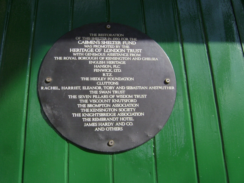
Cabmen's shelter. Erected in 1897 to design of 1882 by the architect
Maximilian Clarke. Timber frame, with timber cladding and overlapping timber
boards to low pitched half-hipped roof, with overhanging eaves. 1 storey. 7
main bays by 3 bays. Entrance to south-west end. Horizontal and vertical
members of frame expressed with panels of vertical boarding set between. 3
square headed 6 pane windows to sides, with glazing bars; pivoting lights
above, with fretwork panels between below eaves. Louvred gablets to ends and
to each side, and square louvre to centre of roof with tented rooflet. A rare
intact surviving example of this design.
Listing NGR: TQ2709279062
External links are from the relevant listing authority and, where applicable, Wikidata. Wikidata IDs may be related buildings as well as this specific building. If you want to add or update a link, you will need to do so by editing the Wikidata entry.


Other nearby listed buildings
