Approximate Location Map
Large Map »
Latitude: 51.3341 / 51°20'2"N
Longitude: 0.1813 / 0°10'52"E
OS Eastings: 552049
OS Northings: 161705
OS Grid: TQ520617
Mapcode National: GBR T1.NCX
Mapcode Global: VHHPD.3Q5M
Plus Code: 9F3285MJ+JG
Entry Name: Waterhouse
Listing Date: 10 September 1954
Last Amended: 20 September 1976
Grade: II
Source: Historic England
Source ID: 1243739
English Heritage Legacy ID: 447984
ID on this website: 101243739
Location: Shoreham, Sevenoaks, Kent, TN14
County: Kent
District: Sevenoaks
Civil Parish: Shoreham
Built-Up Area: Shoreham
Traditional County: Kent
Lieutenancy Area (Ceremonial County): Kent
Church of England Parish: Shoreham St Peter and St Paul
Church of England Diocese: Rochester
Tagged with: Building
1.
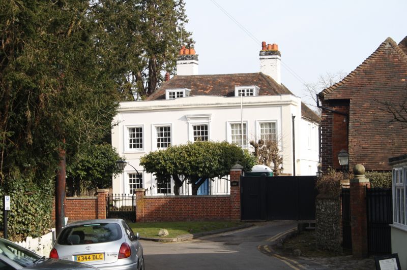
5280 SHOREHAM SHOREHAM
Darent Way
Water ouse
TQ 5261 31/1179 1 .9.54.
II
2.
Early C19 symmetrical stucco elevation of 2 storeys with moulded cornice and
parapet masking older structure. Hip Welsh slate roof with 2 flat-roofed leaded
dormers. Centre C19 panelled door with rectangular light over. Square panelled
pilasters on either side of door with projecting moulded flat hood over supported
on heavy console brackets ornamented with foliage. 2 sash windows on either
side of door with closely spaced glazing bars and with stucco architrave moulded
surrounds and projecting sills. 5 similar sash windows on 1st floor. Bracketed
cornice over centre window. Plaque commemorates Samuel Palmer's staying here
between 1827 and 1835.
Listing NGR: TQ5204961705
External links are from the relevant listing authority and, where applicable, Wikidata. Wikidata IDs may be related buildings as well as this specific building. If you want to add or update a link, you will need to do so by editing the Wikidata entry.


Other nearby listed buildings
