Approximate Location Map
Large Map »
Latitude: 51.3982 / 51°23'53"N
Longitude: 0.538 / 0°32'16"E
OS Eastings: 576650
OS Northings: 169634
OS Grid: TQ766696
Mapcode National: GBR PPP.BTQ
Mapcode Global: VHJLV.83SY
Plus Code: 9F329GXQ+76
Entry Name: Dockyard Canteen
Listing Date: 6 June 1984
Last Amended: 5 December 1996
Grade: II
Source: Historic England
Source ID: 1259641
English Heritage Legacy ID: 462669
ID on this website: 101259641
Location: Brompton, Medway, Kent, ME4
County: Medway
Electoral Ward/Division: River
Parish: Non Civil Parish
Built-Up Area: Gillingham
Traditional County: Kent
Lieutenancy Area (Ceremonial County): Kent
Church of England Parish: Gillingham St Mark
Church of England Diocese: Rochester
Tagged with: Architectural structure
TQ7669NE
686-1/2/99
GILLINGHAM
Pembroke
NORTH ROAD (south side)
Dockyard Canteen
(Formerly Listed as: NORTH ROAD (South side) Canteen in HM Dockyard)
06/06/84
GV
II
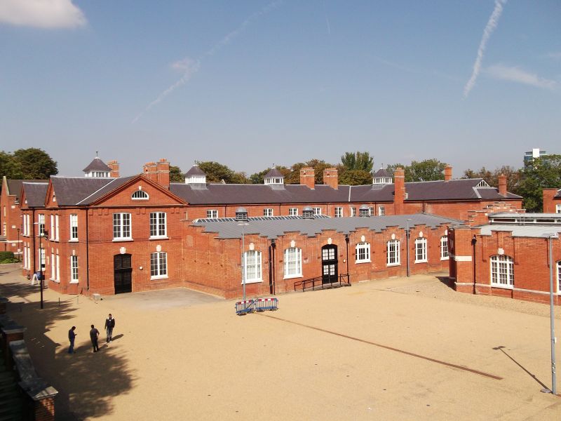
Drill block and offices, canteen, now disused. c1902, by Sir Henry Pilkington. Brick with brick and Portland stone dressings and slate cross-gabled roof.
PLAN: rectangular plan drill hall with cross-axial end blocks.
EXTERIOR: two storeys and attic; eleven window range ends, sixteen window range west elevation. A symmetrical building with matching end ranges; plinth, first floor brick cill band, and brick cornice with flat vertical brackets, and moulded eaves. Ends have projecting two window gables with canted sides, separated by a three window entrance section containing a wide round arch on stone springers with raised keystone and voussoirs, and wrought-iron balcony railing above, to recessed half-glazed doors; a two window section extends to the east.
The main elevation has outer gable as the ends, flanked by three storey canted towers,with banded brick and Portland stone to the parapeted top storey with keyed oculi; between the towers a six window section, with two later single-storey gabled two window blocks added to the middle. Rubbed brick segmental arches to 4/4-pane sashes, paired to the west front the towers, and keyed lunettes in the gables. The ridge of the long range has two square lanterns with pyramidal roofs.
INTERIOR: not inspected.
HISTORY: part of a complete early C20 barracks, with the Captain's House, mess block (Central Ave.), barracks (Pasley Rd), and walls (qqv).
Listing NGR: TQ7665069634
External links are from the relevant listing authority and, where applicable, Wikidata. Wikidata IDs may be related buildings as well as this specific building. If you want to add or update a link, you will need to do so by editing the Wikidata entry.


Other nearby listed buildings
